Central Saanich
| Central Saanich | ||
|---|---|---|
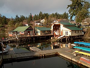
 The harbor at Brentwood Bay |
||
| Location in British Columbia | ||
|
|
||
| State : |
|
|
| Province : | British Columbia | |
| Regional District : | Capital Regional District | |
| Coordinates : | 48 ° 34 ′ N , 123 ° 24 ′ W | |
| Height : | 50 m ( 0 m - 120 m ) | |
| Area : | 41.33 km² | |
| Residents : | 16,814 (as of 2016) | |
| Population density : | 406.8 inhabitants / km² | |
| Time zone : | Pacific Time ( UTC − 8 ) | |
| Postal code : | V8L | |
| Foundation : | 1950 (incorporated) | |
| Mayor : | Alastair Bryson | |
Central Saanich is a district ( District municipality ) on the Saanich Peninsula on Vancouver Island in the Canadian province of British Columbia . The community is part of the Greater Victoria metropolitan area , in the Capital Regional District , which includes several other locations.
location
Central Saanich borders the North Saanich district in the north and the city of Saanich in the south . The district is bounded to the east by Haro Street and to the east by Saanich Inlet .
The following neighborhoods currently make up the district :
- Brentwood Bay
- Island View
- Saanichton
- Keating
- Tanner Ridge
The district still encloses the Indian reservation East Saanich 2 of the Tsawout First Nation on the east coast and South Saanich 1 of the Tsartlip First Nation on the west coast .
history
The first European settlers settled on the peninsula in 1852. Including the first in the area of today's Central Saanich district. At that time this area was still called South Saanich. However, it is true for this area that it was a hunting and fishing area of various First Nations tribes long before the arrival of the first European settlers.
On the settlements the local self-government (incorporated) was granted.
The award of local self-government for the settlement in the center of the Saanich Peninsula took place on December 12, 1950 ( incorporated as District Municipality ).
The small district continued to develop in the following years. In 1951, for example, a police force and fire department were founded.
Demographics
The last official census , the 2016 Census , showed a population of 16,814 inhabitants for the settlement, after the 2011 census for the municipality still showed a population of 15,936 inhabitants. The population increased by 5.5% compared to the last census in 2011 and developed with the provincial average, there with a population increase of 5.6%. In the census period from 2006 to 2011, the population in the municipality only decreased by 1.2%, while the provincial average increased by 7.0%.
At the 2016 census, the average age of the residents was 46.7 years, well above the provincial average of 42.3 years. The median age of the residents was determined to be 50.4 years. The median age of all residents in the province in 2016 was 43.0 years. For the 2011 census, a median age of 49.1 years was determined for the inhabitants of the municipality, and 41.9 years for the inhabitants of the province.
traffic
Through the area the district runs north-south on Highway 17 and connects Victoria with the Swartz Bay Ferry Terminal .
There is also a small BC Ferries ferry from Brentwood Bay Ferry Terminal across Saanich Inlet to Mill Bay .
tourism
Butchart Gardens is the biggest tourist attraction in the district and one of the biggest attractions on southern Vancouver Island . This is a private flower garden built in 1904, which can be visited today. English landscaping and horticulture is very common in this region.
Web links
- Central Saanich , homepage of the district
Individual evidence
- ^ A b Central Saanich Community Profile. Census 2016. In: Statistics Canada . August 9, 2019, accessed September 4, 2019 .
- ^ Origin Notes and History. Central Saanich. GeoBC , accessed September 4, 2019 .
- ^ Central Saanich Community Profile. Census 2011. In: Statistics Canada . May 31, 2016, accessed September 4, 2019 .
