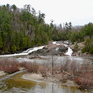
Chippewa River (Lake Superior)
| Chippewa River | ||
|
Chippewa Falls |
||
| Data | ||
| location | Algoma District in Ontario (Canada) | |
| River system | Saint Lawrence River | |
| Drain over | Saint Marys River → St. Clair River → Detroit River → Niagara River → Saint Lawrence River → Atlantic Ocean | |
| source | south of Dyson Lake 47 ° 9 ′ 55 ″ N , 83 ° 56 ′ 39 ″ W |
|
| Source height | approx. 450 m | |
| muzzle | to Batchawana Bay ( Lake Superior ) Coordinates: 46 ° 55 ′ 38 " N , 84 ° 26 ′ 21" W 46 ° 55 ′ 38 " N , 84 ° 26 ′ 21" W |
|
| Mouth height | 184 m | |
| Height difference | approx. 266 m | |
| Bottom slope | approx. 4.4 ‰ | |
| length | approx. 60 km | |
| Left tributaries | East Branch Chippewa River | |
The Chippewa River is a tributary of Lake Superior in the Canadian province of Ontario .
The Chippewa River has a length of about 60 km. Shortly before its mouth, it overcomes the Chippewa Falls . It finally flows 55 km north of Sault Ste. Marie to Batchawana Bay . The Trans-Canada Highway ( Ontario Highway 17 ) crosses the river near the mouth. The Harmony River runs east of the Chippewa River and the Batchawana River runs west .
The river is considered a good and easily accessible fishing spot. Rainbow trout can be caught here in spring .
