
Chota (Tennessee)
| Chota (Tennessee) | |||
|---|---|---|---|
| National Register of Historic Places | |||
 Monument to the town of Chota |
|||
|
|||
| location | Monroe County , Tennessee | ||
| Coordinates | 35 ° 33 '18 " N , 84 ° 7' 52" W | ||
| Built | between 1600 and 1745 | ||
| Architectural style | Indian settlement | ||
| NRHP number | 73001813 | ||
| The NRHP added | 1973 | ||

Chota ( Chota and Tanasi Cherokee Village Sites , also: Chote , Echota , Itsati, etc.) is a historic Overhill Cherokee settlement on the Little Tennessee River in Monroe County, Tennessee , in the southeastern United States . The settlement developed after the nearby Tanasi from the late 1740s to 1788. Then Chota was the most important of the "Overhill Towns" and replaced Tanasi as the de facto capital of the Cherokee . It is estimated that the settlement had up to 500 residents.
Numerous prominent Cherokee chiefs were born or resided in Chota, including Attakullakulla , Oconostota , Kanagatucko (Old Hop), Old Tassel , Hanging Maw and Nancy Ward .
1979 both places were largely flooded by the impoundment of the Tellico Lake Impoundment (Tellico Lake). Previously carried out archaeological excavations showed that the settlement had a town house. The Chota monument is right above the old town house. The archaeological sites of Chota and Tanasi were jointly listed on the National Register of Historic Places ; Tanasi was also classified as an Archaeological Site (40MR62) in 1972.
The location of the Chota Townhouse was found during the excavations. The area was raised above the water level of the reservoir and connected to the bank with a dam. The Chota Monument, which now stands directly above the townhouse, consists of eight columns, one for each of the seven Cherokee clans and one for the entire nation. The grave of Chief Oconostota , which had already been uncovered during excavations in 1969, was also reburied at the monument. This site is now administered by the Eastern Band of the Cherokee .
geography
The Little Tennessee River comes to Tennessee from its sources in the Appalachian Mountains and flows for about 70 km through parts of Blount , Monroe, and Loudon Counties before flowing into the Tennessee River at Lenoir City . Tellico Lake , created by the Tellico Dam in 1979, covers the 45 km in the lower reaches of the river. The site of Chota is approximately 42 km above the river mouth, opposite a sharp bend in the river known as Bacon's Bend .
Both Chota and Tanasi were laid out by the Cherokee on a relatively flat terrace flanked by steep hills that rise to the south. These hills are part of the Appalachian Ridge-and-Valley Physiographic Province , which is characterized by narrow, elongated ridges and steep hills. The Great Smoky Mountains and the Unicoi Mountains , both sub-areas of the main ridge of the Appalachians, rise a few miles to the southeast and southwest.
The Tanasi and Chota Monuments are right next to Highway 360 (Citico Road) on Bacon Ferry Road , which ends at a parking lot. A short walk connects the car park with the Chota Monument.
history
Ascent of Chota
Chota does not appear in historical sources before 1745. Tanasi is mentioned much earlier, namely as a starting point or destination for numerous traders and diplomats. While Tanasi is also featured on many maps of the Overhill Territory drawn in the 1720s and 1730s, Chota does not appear. This could indicate that Chota was part of Tanasi before 1740, or was not yet considered a separate city. In the 1720s, the "head man of Tanasi", simply referred to as the "Tanasi Warrior", was the chief of the Overhill Towns in what is now Tennessee and the "Middle" and "Valley towns" in North Carolina.
In 1730 Moytoy of Tellico was crowned "Emperor of the Cherokee" with the support of the extravagant emissary Alexander Cuming . This moved the seat of the capital to his city of Great Tellico , where Moytoy himself was chief. When Moytoy died in 1741, his son Amouskositte tried in vain to succeed him as Emperor. Old Hop, the chief in Chota, began to consolidate his power and in 1753 Chota replaced Great Tellico as the "mother town" of the Overhill Cherokee.
Around this time, on the eve of the French and Indian War , the Cherokee were more on the side of the French, which caused the English colonists of Virginia and South Carolina to intensify contact with the Overhill Towns. Virginia dispatched Major Andrew Lewis with 60 men to build a fort at Chota. This was completed in August 1756. However, it was never garrisoned because the Cherokee allied with the English against the French. Later that year, South Carolina dispatched engineer William de Brahm with 300 men to build Fort Loudoun , which was completed in March 1757. However, by 1760, relations between the English and the Cherokee had deteriorated and the conflict led to the Anglo-Cherokee War . The Chota warriors took prey in the post- siege pillage of Fort Loudoun .
Timberlake's visit 1761–62

After the fall of Fort Loudoun, the Overhill Towns asked for peace, which was achieved with the Treaty of Long Island in 1761. Virginia dispatched a delegation led by Henry Timberlake to consolidate peace with the Overhill Towns. He reached Chota in December 1761, accompanied by Ostenaco (the head Cherokee Man of Tomotley ). The ceremony in the Chota meeting house, at which Ostenaco ceremonially buried an ax, became a symbol of peace between the British and the Cherokee. Timberlake spent the night in Old Hop's "hot-house" (a circular cabin used by the Overhill Cherokee in the cold months) before traveling to Citico the next day .
Timberlake's “Draft of the Cherokee Country” has 52 residential buildings and a meeting house in Chota. Kanagatucko (Old Hop) was referred to as the "Governor" by both Chota and Tanasi. The 175 warriors available in Chota formed the second largest contingent among the Overhill Towns, after Citico.
Decline
At the outbreak of the War of Independence , the Cherokee allied themselves with the British in the hope of driving the American colonists out of their territory. In 1776, Dragging Canoe (Head Man of Mialoquo ) and Old Abraham of Chilhowee carried out an unsuccessful two-part attack on Fort Watauga and Heaton's Station . In return, Virginia sent Colonel William Christian with a small force to subdue the Overhill Towns. Christian penetrated the Little Tennessee Valley unhindered and negotiated a contract with Attakullakulla and Oconastota. When Dragging Canoe refused to negotiate, however, Christian destroyed the cities of Great Tellico, Citico, Mialoquo, Chilhowee and Toqua .
In 1780, recently returned from the Battle of Kings Mountain , John Sevier led an invasion of Overhill Country in retaliation for several attacks on American settlements by defiant Cherokees. Most of the remaining Overhill Towns, including Chota, were destroyed. Chota was rebuilt until 1784, but it never fully recovered. In 1788, Old Tassel, the chief of the Overhill Towns after the death of Oconastota, was murdered by Americans under a negotiating flag near Chilhowee. Mainly because of this incident, the Cherokee moved their capital south to Ustanali , near what is now Calhoun , Georgia .
In the late 1790s, the Duke of Orleans visited the Tellico Blockhouse while touring East Tennessee. Louis-Philippe watched 600 Cherokees "ballplay" at Chota and bet 6 gallons of brandy on the outcome of the game. At that time there were only five buildings left on the site.
archeology

Cyrus Thomas of the Smithsonian Institution performed a mapping of earthworks in the Little Tennessee Valley in the 1880s . Thomas excavated a mound on the site of Chota and discovered several artifacts. In 1939, a team from the University of Tennessee led by Thomas Lewis and Madeline Kneburg excavated Chota with the help of workers paid by the Works Projects Administration . Their finds, which Lewis and Kneburg expected to provide comparable data for their Hiwassee Island Findings , comprised 85 pits, 12 burial sites and one building.
After the Tennessee Valley Authority published their plans to build Tellico Dam in 1967, which sank historic Cherokee sites, the University of Tennessee initiated a plan for archaeological rescue excavations in the Little Tennessee Valley. The excavations were carried out in Chota between 1969 and 1974 when legal disputes delayed the dam project. The excavations uncovered 783 structures (mostly rubbish pits), as well as the imprints of 31 structures and 91 burial sites. Burial 10 , a grave that was excavated in 1969, was identified as that of Chief Oconostota by grave goods (including a pair of wire spectacles ). Thousands of stone and ceramic artifacts have been unearthed, including arrowheads dated to the Archaic period in the Americas (8000-1000 BC).
The structures uncovered at Chota also included two townhouses, one 60 ft (18 m) in diameter and another just over 50 ft (15 m) in diameter. The smaller building, which might be a bit older, could have been the Tanasi Townhouse. Other structures included a summer pavilion (48 ft × 23 ft - 14.6 m × 7 m) adjacent to a village plaza measuring 100 ft (30 m) × 160 ft (48.7 m) and 11 ensembles of rectangular summer cottages and round winter huts. The buildings were set up at intervals of between 12 m and 30 m and were up to 610 m away from the townhouse. One of the buildings was assigned to the Early Mississippian Culture (c. 1000-1300 AD), while the other was assigned to the Cherokee.
In 1986, the dead that had been excavated in Chota were reburied in a burial mound at the Sequoyah Museum near Vonore . An exception were the remains of Oconostota, which were buried at the Chota Monument above the townhouse, as the Cherokee wished.
Chota Monument
The monument consists of a circle of seven concrete columns with pictograms on top. The pillars represent the seven clans and the Cherokee nation as a whole.
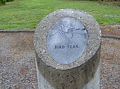
"Anitsiskwa" - Bird Clan
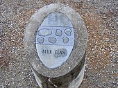
"Anisahoni" - Blue Clan
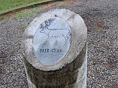
"Anikawi" - Deer Clan
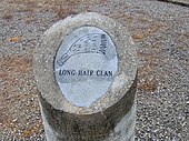
"Ani-gilohi" - Long Hair Clan

"Aniwodi" - Paint Clan
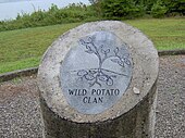
"Anigatagewi" - Wild Potato Clan
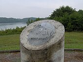
"Aniwaya" - Wolf Clan


Individual evidence
- ↑ Gerald Schroedl: Chota. In: The Tennessee Encyclopedia of History and Culture. 2009.
- ^ David Ray Smith: Nancy Ward. In: The Tennessee Encyclopedia of History and Culture. 2009.
- ↑ Gerald Schroedl (ed.): Overhill Cherokee Archeology at Chota-Tanasee. University of Tennessee Department of Anthropology, Report of Investigations 38, 1986: 9.
- ↑ Schroedl: Overhill Cherokee Archeology at Chota-Tanasee : 9.
- ^ Samuel Cole Williams: Early Travels in the Tennessee Country, 1540-1800. Johnson City, Tennessee: The Watauga Press 1928: pp. 97-101.
- ^ Williams: Early Travels. Pp. 122-127.
- ↑ Jefferson Chapman : Tellico Archeology: 12,000 Years of Native American History. Tennessee Valley Authority 1985: p. 104.
- ↑ Schroedl: Overhill Cherokee Archeology at Chota-Tanasee. P. 9.
- ↑ Schroedl: Overhill Cherokee Archeology at Chota-Tanasee. Pp. 10-12.
- ^ Henry Timberlake, Samuel Cole Williams (ed.): Memoirs, 1756-1765. Marietta, Georgia: Continental Book Co. 1948: pp. 59-62.
- ↑ Schroedl: Overhill Cherokee Archeology at Chota-Tanasee. Pp. 12-13.
- ^ Inez Burns: History of Blount County, Tennessee: From War Trail to Landing Strip, 1795-1955. Nashville: Benson Print Co. 1957: pp. 11-16.
- ↑ Schroedl: Overhill Archeology at Chota-Tanasee. P. 14.
- ^ Alberta and Carson Brewer: Valley So Wild. Knoxville, Tennessee: East Tennessee Historical Society 1975: p. 58.
- ^ Brewer and Brewer: Valley So Wild. P. 58.
- ↑ Schroedl: Overhill Cherokee Archeology at Chota-Tanasee. P. 14.
- ↑ Schroedl: Overhill Cherokee Archeology at Chota-Tanasee. Pp. 16-20.
- ↑ Schroedl: Overhill Cherokee Archeology at Chota-Tanasee. Pp. 38-39.
- ↑ Schroedl: Overhill Cherokee Archeology at Chota-Tanasee. Pp. 134-136.
- ↑ Schroedl: Overhill Cherokee Archeology at Chota-Tanasee. Pp. 379, 544.
- ↑ Schroedl: Overhill Cherokee Archeology at Chota-Tanasee. Pp. 263-287.
- ↑ Schroedl: Overhill Cherokee Archeology at Chota-Tanasee. P. 217.
- ↑ Schroedl: Overhill Cherokee Archeology at Chota-Tanasee. P. 204.