Little Tennessee River
| Little Tennessee River | ||
|
upper Tennessee River basin |
||
| Data | ||
| Water code | US : 1013036 | |
| location | US states of Tennessee , North Carolina, and Georgia | |
| River system | Mississippi River | |
| Drain over | Tennessee River → Ohio River → Mississippi River → Gulf of Mexico | |
| confluence | several mountain streams in Rabun County , Northeast Georgia 34 ° 55 ′ 49 ″ N , 83 ° 26 ′ 12 ″ W |
|
| muzzle |
Tennessee River near Lenoir City Coordinates: 35 ° 46 ′ 57 " N , 84 ° 15 ′ 35" W 35 ° 46 ′ 57 " N , 84 ° 15 ′ 35" W |
|
| Mouth height |
226 m
|
|
| length | 217 km | |
| Left tributaries | Tellico River | |
| Right tributaries |
Cullasaja River , Tuckasegee River |
|
| Reservoirs flowed through | Fontana Lake , Tellico Reservoir , Cheoah Dam | |
|
The Tellico Reservoir, reservoir on the Little Tennessee River |
||
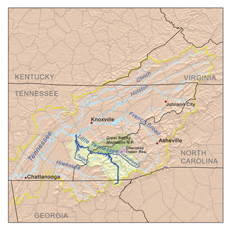
The Little Tennessee River is a 217 km long tributary of the Tennessee River in the Appalachian Mountains . It flows through the three US states of Georgia , North Carolina and Tennessee .
course
The source of the Little Tennessee River is the confluence of several mountain streams in the Blue Ridge Mountains in the Chattahoochee National Forest in northeast Rabun County . The river initially flows east but then turns north to flow along US Highway 441 past Dillard and pick up more streams. After flowing through the North Carolina border, the river arrives in the Nantahala National Forest . After some time the highway leaves the river, which now reaches Franklin , where the Cullasaja River flows from the right. After that, the Little Tennessee River flows through Lake Emory and for some time flows near North Carolina State Highway 28 , turning more and more to the northwest. After flowing further north, passing under US Highway 19 , the Great Smoky Mountains Expressway, it flows into Fontana Lake , a large reservoir that extends westward with many bays, headlands and islands. He reaches the area of the Great Smoky Mountains National Park . After the river has passed the Fontana Dam , North Carolina State Highway 28 now runs right along the river bank. Back in the Nantahala National Forest, the river reaches Cheoah Lake , along its northern bank is US Highway 129 , which is the western end of North Carolina State Highway 28.
The Little Tennessee River forms the boundary of the Nantahala National Forest and eventually reaches Tennessee. There it forms the northern limit of the Cherokee National Forest and flows in some meanders in Calderwood Lake . US Highway 129 , the Calderwood Highway, now runs along the river, which then reaches Chilhowee Lake . Soon after, the huge Tellico Reservoir determines the entire course of the river, into which the Tellico River also flows. It extends to just before the confluence with the Tennessee River at Lenoir City . On the banks of the reservoir are the two recreational areas Fort Loudon State Historic Park and McGee Carson Peninsula State Historic Park . The reservoir is also spanned by US Highway 411 .
Reservoirs
As mentioned in the previous section, the Tennessee Valley Authority established several reservoirs in the Little Tennessee River valley in North Carolina and Tennessee. They serve to avoid flooding and to generate hydropower. Three of these reservoirs go back to the company Alcoa , which operated its aluminum works in Alcoa (Tennessee) with hydropower .
history
Prehistoric settlement
The Little Tennessee River valley has many archaeological sites dating back to 7500 BC. From the time of the Archaic period, which dates Icehouse Bottom -Stätte and Rose Iceland -Stätte near the confluence with the Tellico River. Its inhabitants may have used the chert from the cliffs to make tools. There are also some Woodland Period sites along the river, such as B. Calloway Island , Thirty Acre Island and Bacon Bend as well as the two above mentioned sites. Its residents apparently had connections to the Hopewell culture . The following sites come from the Mississippi culture : Toqua , Tomotley , Citico and Bussell Island . In the 15th century, the Toqua settlement was demarcated by a palisade covered with clay.
Cities of the Cherokee
In the area of the North Carolina river course were several Cherokee cities , including Nikwasi , Jore, and Cowee . The Overhill Cherokee were Cherokee settlements in what is now Tennessee, including Chota , Tanasi , Mialoquo , Toqua, Tomotley, Tallassee and Tuskegee .
European settlement
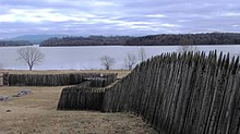
The first Europeans came to the Little Tennessee River area in the late 17th century, and Hernando de Soto and Juan Pardo explored the area in 1540 and 1567 . In 1756 the English built Fort Loudoun at the confluence of the Little Tennessee River and the Tellico River. This fort was reconstructed and can be visited today. The Europeans erect other buildings with the Tellico Blockhouse at the confluence of Nine Mile Creek and the Morganton settlement , which was near the present-day Greenback and served as a port on the Little Tennessee River.


