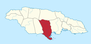
Clarendon Parish
| Clarendon | |
| Capital | May Pen |
| county | Middlesex |
| surface | 1,196 km² |
| population | 247,109 (2009) |
| Population density | 206.6 / km² |
| economy | Agriculture, bauxite mining |

|
|
Clarendon is a district ( parish ) in southern Jamaica . The capital is May Pen .
history
Clarendon is named after the Lord Chancellor and Earl of Clarendon Sir Edward Hyde . There was a parish with this name before. Today's Clarendon emerged from this and from the districts of Saint Dorothy's and Vere.
The capital May Pen was founded by English settlers between 1660 and 1683.
geography
Clarendon is bordered by Manchester to the west, Saint Catherine to the east, and Saint Ann to the north . Portland Point , the southernmost point of Jamaica, is located on a peninsula . In 2001, 215,515 people lived on 1,196 km², 49,928 of them in the capital.
Most of the parish is a wide plain, bordered by rivers. One of the rivers is the Rio Minho , which flows through Clarendon along its entire length. In the north is the Bull Head Mountain range , which is over 900 meters high and is considered the geographic center of Jamaica.
economy
Most of Jamaican tobacco comes from Clarendon. In addition, cotton , allspice , ginger , bananas , cocoa and the dye indigo are grown. Livestock and fish farming also play an important role. There are large deposits of bauxite . A port in the south has specialized in its export. At times copper was also mined.
Web links
- Statistical Institute of Jamaica (Engl.)
- Clarendon (Eng.)
Individual evidence
- ↑ Statistical Institute of Jamaica: Demographic Statistics - Population by Parish 2009 ( Memento of the original dated November 13, 2010 in the Internet Archive ) Info: The archive link was inserted automatically and has not yet been checked. Please check the original and archive link according to the instructions and then remove this notice. . Retrieved November 15, 2010.
Coordinates: 17 ° 58 ′ N , 77 ° 15 ′ W