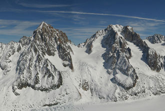
Col du Chardonnet
| Col du Chardonnet | |||
|---|---|---|---|
|
Col du Chardonnet between Aiguille du Chardonnet (left) and Aiguille d'Argentière |
|||
| Compass direction | west | east | |
| Pass height | 3323 m | ||
| Haute-Savoie ( France ) | Canton of Valais ( Switzerland ) | ||
| Valley locations | Argentière | Praz de Fort | |
| expansion | Alpine route (alpine transition) | ||
| Mountains | Mont Blanc massif | ||
| map | |||
|
|
|||
| Coordinates , ( CH ) | 45 ° 57 '58 " N , 7 ° 0' 43" O ( 566915 / 90609 ) | ||
The Col du Chardonnet is a 3323 m high, glaciated mountain pass in the eastern Mont-Blanc massif . The border between Switzerland and France runs over the top of the pass .
The Col du Chardonnet is located between the Aiguille du Chardonnet in the north and the Aiguille d'Argentière in the south. It is a frequently used transition between the Glacier d'Argentière in the west and the eastern Saleina glacier , from which the Trient glacier can be reached via the Fenêtre de Saleina . The bases are the Refuge d'Argentière on the French side and the Trienthütte and the Cabane de Saleina on the Swiss side . The Col is committed as a ski tour in both summer and winter . The first stage of the Haute Route leads over the Col du Chardonnet.

