
Coln St. Aldwyns
| Coln St. Aldwyns Coln St. Aldwyn |
|||
|---|---|---|---|
|
|||
| Coordinates | 51 ° 45 ′ N , 1 ° 47 ′ W | ||
| Basic data | |||
| Country | United Kingdom | ||
|
Part of the country |
England | ||
| county | Gloucestershire | ||
| ISO 3166-2 | GB-GLS | ||
| South West England | |||

Coln St. Aldwyns even Coln St Aldwyn is a village and civil parish in the county of Gloucestershire ( England ) in the Cotswolds . It is located in the River Coln Valley , 3 miles from Bibury and Fairford and 9 miles from Cirencester . The parish is part of the Riversmeet- Ward (administrative unit) and the parliamentary constituency and district of Cotswold , which is named after the Cotswolds landscape.
The parish church of St. John the Baptist from Norman times , expanded in the 13th to 15th centuries, is located in the far south of the parish and is also responsible for some neighboring places. The New Inn at Coln restaurant dates back to the 18th century. Many houses from the 17th and 18th centuries are built from natural stone in the traditional Cotswold style.

St. John the Baptist
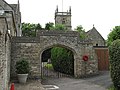
Church gate

Mill
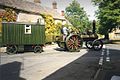
Local road with steam tractor


Web links
- Web site Coln St. Aldwyns (accessed on 13 September 2012)
- Coln St. Aldwyns' picture gallery on PicturesOfEngland, accessed September 13, 2012