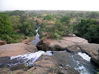
Comoé (river)
|
Comoé Komoé |
||
|
The Comoé river system |
||
| Data | ||
| location |
|
|
| River system | Comoé | |
| source | near Banfora in Burkina Faso | |
| Source height | about 500 m | |
| muzzle |
Gulf of Guinea ; ( Ébrié Lagoon ) Coordinates: 5 ° 11 ′ 30 " N , 3 ° 43 ′ 20" W 5 ° 11 ′ 30 " N , 3 ° 43 ′ 20" W. |
|
| Mouth height | 0 m | |
| Height difference | about 500 m | |
| Bottom slope | about 0.43 ‰ | |
| length | 1160 km | |
| Catchment area | 78,000 km² | |
| Discharge at the Aniassue gauge (1428400) A Eo : 67,400 km² Location: 300 km above the mouth |
NNQ (min. Month Ø) MNQ 1980–1994 MQ 1980–1994 Mq 1980–1994 MHQ 1980–1994 HHQ (max. Month Ø) |
0 l / s 1.3 m³ / s 106 m³ / s 1.6 l / (s km²) 467 m³ / s 1020 m³ / s |
| Left tributaries | Bawe, Iringou , Congo, Diore , Ba , Beki, Manzan | |
| Right tributaries | Léraba , Kolonkoko, Kinkene, Segbono | |
| Medium-sized cities | Banfora , Aniassué | |
|
The Cascades de Karfiguéla or Banforafäll in the upper reaches of Comoé |
||
The Comoé is a 1160 km long river in Burkina Faso and the Ivory Coast . It is one of the main rivers in the Ivory Coast.
course
It has its source in southwest Burkina Faso and runs south. When crossing the border with Ivory Coast, it takes in its largest tributary, the Léraba, from the west. It then flows through the Comoé National Park named after him in the northeast of the Ivory Coast state. It flows further from north to south and flows into the Gulf of Guinea or the Ébrié lagoon about 80 km east of Abidjan .
Apart from the shorter Iringou, the Comoé is the only river in the region that carries water even in the dry season. However, there are periods when the river becomes stagnant water.
Hydrometry
The flow rate of the river was measured in Aniassue in almost 90% of the catchment area in m³ / s

Catchment area
The catchment area of the Comoé has a size of about 78,000 km². 57,300 km² of this is in the Ivory Coast. This corresponds to 17.6% of the country's area.
| Rivers | Total area [km²] | Area in the Ivory Coast [km²] |
|---|---|---|
| Leraba | 11,200 | 4,900 |
| Bawe | 2,300 | 1,000 |
| Colonic coconut | 1,800 | 1,800 |
| Iringou | 6,700 | 5,600 |
| Congo | 2,400 | 2,400 |
| Kinkene | 3,200 | 3,200 |
| Segbono | 1,200 | 1,200 |
| Diore | 5,000 | 5,000 |
| Ba | 7,400 | 6,100 |
| Beki | 700 | 700 |
| Manzan | 3,500 | 2,000 |
| Comoé overall | 78,000 | 57,300 |
Individual evidence
- ↑ a b c d JICA publication
- ↑ a b GRDC - Aniassue level

