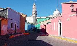
Cosalá
| Cosalá | ||
|---|---|---|
|
Coordinates: 24 ° 25 ′ N , 106 ° 42 ′ W Cosalá on the map of Sinaloa
|
||
| Basic data | ||
| Country | Mexico | |
| State | Sinaloa | |
| Municipio | Cosalá | |
| City foundation | 1562 | |
| Residents | 6577 (2010) | |
| City insignia | ||
| Detailed data | ||
| surface | 4.34 km 2 | |
| Population density | 1,515 inhabitants / km 2 | |
| height | 380 m | |
| Post Code | 80700 | |
| prefix | (+52) 696 | |
| Website | ||
| Cosalá - the townscape | ||
Cosalá is a small town with about 6,500 inhabitants and the administrative seat of the municipality of the same name (municipio) with a total of about 15,000 inhabitants in the Mexican state of Sinaloa . Because of its historic city center, it has been one of the Pueblos Mágicos since 2005 .
location
The place Cosalá is surrounded by the wooded mountains of the Sierra Madre Occidental at an altitude of approx. 380 m . Culiacán , the capital of the state, is approximately 115 km (driving distance) northwest; the port city of Mazatlán is about 165 km south on the coast of the Gulf of California . The climate is temperate to warm; Rain (approx. 750 mm / year) falls almost exclusively in the summer half-year.
Population development
| year | 2000 | 2005 | 2010 |
| Residents | 5,675 | 6,822 | 6,577 |
The slight increase in population is mainly due to the immigration of families and individuals from the surrounding villages. Most of the community's residents, who are often Native American and Nahuatl- speaking, also speak Spanish.
economy
Silver ore was mined in the area around Cosalá until the middle of the 20th century . Cattle are raised in the villages of the municipality, along with corn, wheat, beans and vegetables; there are also numerous mango trees. In the small town itself, smaller trade shops as well as craft and service companies have settled.
history
Before the arrival of the Spaniards, the area was populated by various Indian tribes, even if only very thinly. Cosalá was founded on March 13, 1562 by Francisco de Ibarra under the name Quetzalla ; Franciscans arriving later gave the place the name Real de Minas de Nuestra Señora de las Once Mil Vírgenes de Cosalá . After Mexico gained independence (1821), Cosalá belonged to the largely independent area of the Estado de Occidente for six years (1824-1830) .
Attractions
- Cosalá has most of its visitors because of its colonial atmosphere.
- The Iglesia de Santa Ursula with its bell tower dates from the 18th century. As usual, the church has a single nave; the yoke in front of the apse is vaulted with a dome that rests on a furrowed drum .
- The Museo de Minería y Historia offers insights into the mining industry in the region.
- Surroundings
- The wooded surroundings of the place offer numerous hiking opportunities along waterfalls (cascadas) waterfalls and rock caves (cuevas) .

