Council Grove
| Council Grove | |
|---|---|
 Downtown |
|
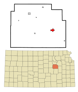
| Location in Kansas | |
| Basic data | |
| Foundation : | 1847 |
| State : | United States |
| State : | Kansas |
| County : | Morris County |
| Coordinates : | 38 ° 40 ′ N , 96 ° 29 ′ W |
| Time zone : | Central ( UTC − 6 / −5 ) |
| Residents : | 2,321 (as of: 2000) |
| Population density : | 504.6 inhabitants per km 2 |
| Area : | 4.6 km 2 (approx. 2 mi 2 ) of which 4.6 km 2 (approx. 2 mi 2 ) is land |
| Height : | 377 m |
| Postcodes : | 66846, 66873 |
| Area code : | +1 620 |
| FIPS : | 20-15925 |
| GNIS ID : | 0477021 |
Council Grove is a small town in the US state of Kansas and the seat of the administration of Morris County . The place with 2321 inhabitants (2000) is located on the east bank of the Neosho River immediately south of the Council Grove Lake reservoir . In place of crossing US Highway 56 the river. Here it follows the Santa Fe Trail , a historic trade route which, in the mid-19th century, represented the cultural and economic connection between the populated regions on the Missouri River, around 100 km away, and the initially Mexican southwest.
history
The place owes its name to a meeting of the Osage Indians in 1825 at which Commissioner George C. Sibley, on behalf of the US government, bought merchants' right to free passage through the people's territory for goods worth $ 800. As early as 1822, the first year of trade on the route, the initially few travelers had crossed the wide but shallow Neosho River at or near the site of today's location.
On the river there were large forests that set themselves apart from the prairies of what would later become Kansas, so that an important resting place on the trail was established because of the good supply of firewood.
1846 the area became a reserve of Kansas reported and established a trading post. It was the core of the later settlement. In the same year, the Mexican-American War resulted in large movements of troops on the trail. The victory of the United States and the cession of almost all of the western part of what is now the United States of America from Mexico sparked a huge boom in trade.
In 1850 regular mail was started and a station was set up in Council Grove. The building also served as a mission station and school for the Methodist Church and is still a museum today. In 1854 Kansas was established as a Territory, and in 1857 the settlement had advanced so far that Council Grove was worth a shop and restaurant, which not only catered for the merchants, but also the growing population of the region.
The Hays House restaurant still exists today and is the longest-running restaurant west of the Mississippi River . Seth Hays, the founder, was a great-grandson of Daniel Boone and cousin of Kit Carson , the deed of land purchase was signed by Abraham Lincoln .
In 1861 Kansas became a US state , the Civil War of 1861-65 brought troop movements, but no fighting on the Neosho River. 1866 reached railway construction of the Union Pacific Railroad , the little north to Junction City and ended trading with covered wagon on Council Grove. Settlement continued and in 1871 the Atchison, Topeka and Santa Fe Railway came to Council Grove and continued building to the southwest.
Council Grove today
The place developed into the economic center of the agricultural region and has retained this importance to this day. In addition, the city lives from its history, it attracts tourists with historical buildings under old trees . The historic core of the settlement was recognized as a Council Grove Historic District in May 1963 as a National Historic Landmark .
Web links
- Municipal administration website
- Population statistics for Council Grove
Individual evidence
- ↑ Listing of National Historic Landmarks by State: Kansas. National Park Service , accessed August 3, 2019.
