Crüsemannallee
| Crüsemannallee | |
|---|---|
| Street in Bremen | |
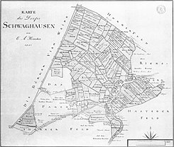
| Schwaghausen: Map by CA Heinenken from 1803; On the left the Bürger Vieh Weide ( Bürgerpark ), next to it the Parkallee and parallel to it above / on the left the line (corridor boundary) on which the Crüsemannallee runs today | |
| Basic data | |
| city | Bremen |
| district | Schwachhausen |
| Created | 20th century |
| Cross streets | Schwachhauser Ring , Coccejusstraße, Emmastraße, Helene-Neesen-Straße, Busestraße, Kulenkampffallee |
| use | |
| User groups | Cars, trams, bicycles and pedestrians |
| Road design | four lane road |
| Technical specifications | |
| Street length | 850 meters |
The Crüsemannallee is a central access road in Bremen , Schwachhausen district, Neu-Schwachhausen district . It mainly leads in a south-north direction from Hartwigstrasse and Schwachhauser Ring to Kulenkampffallee .
The cross streets and connecting streets were named u. a. as Hartwigstraße 1890 after the important Archbishop Hartwig I (1118–1168), Schwachhauser Ring after the Ringstraße around Bremen, Coccejusstraße after the brothers Gerhard (councilor, 1601–1660) and Johannes Coccejus (theologian, 1603–1669), Emmastraße 1890 after the benevolent landowner and Countess Emma von Lesum (975 / 980-1038), Helene-Neesen-Straße after the Bremen women's rights activist and founder of the Bremen housewives' association, Busestraße after the former dairy, Kulenkampffallee 1957 after the old Bremen merchant family and Koenenkampstraße after the silk merchant Wilhelm Koenenkamp (1859-1941); otherwise see the link to the streets.
history
Surname
The Crüsemannallee was named after the businessman and co-founder of the North German Lloyd (NDL) Eduard Crüsemann (1826–1869). He was only 43 years old.
The NDL was founded in 1857 by Hermann Henrich Meier (1809–1898) and Crüsemann as the first director of the Bremen shipping company and by Gustav Kulenkampff (1811–1878).
development
Neu-Schwachhausen was not built on until after the Second World War in the 1960s / 70s. a. by the Bremer Beamtenbaugesellschaft (BBG) and the Bremer Schoss with multi-storey rental houses. The district had 5723 inhabitants (2009). The residential buildings Sparer-Dank Kulenkampffallee , Crüsemannallee and Koenenkampstraße from the Bremer Schoss from 1961 to 1966 based on plans by Gerhard Müller-Menckens , Friedrich Heuer and Gunter Müller are among the most important buildings in Bremen.
traffic
Line 15 went to Hartwigstrasse and was extended from 1960 through Crüsemannallee to Kulenkampffallee. In 1959 the route was Kulenkampffallee - Markt - Airport. In 1967, the previous lines 15 and 16 received the line numbers of the discontinued lines 5 and 6. Line 5 ran from Kulenkampffallee via Domsheide to Huckelriede, with the section Hauptbahnhof - Kulenkampffallee being served together with the new line 8. Line 8 has been running to Kulenkampffallee on its own since winter 2002/03 and since 2006 only during the day to Huchting and in the evening only to the main station.
The Bremen tram has been using line 6 (Kulenkampffallee - Airport) since 2016.
In local transport in Bremen, bus line 22 (Kattenturm-Mitte ↔ Universität-Ost) runs through the street.
Buildings and facilities
The street is mainly built up with two to four-story residential buildings from the period after the Second World War from around 1960 to 1980.
Notable buildings and facilities
East Side
- No. 1 and 3: Two 2-tiered Residential houses as villas with hipped roofs
- No. 7: 1-sch. very modern house with pent roof
- No. 15 to 21a: 3- and 4-layered Residential complex with pitched roofs
- No. 23 to 47: 3-ply Residential complex with pitched roofs
- No. 53 to 69: 3-ply Residential houses with pitched roofs
- Reversing loop of the tram
West side
- No. 2 to 8: 3-ply Residential houses, some with high hipped roofs
- No. 22 to 52: 3-ply Residential houses with pitched roofs, mostly in open row construction
- No. 62 to 76: 3-ply Residential houses with pitched roofs
- No. 78 to 84: 3-ply Residential and commercial buildings with u. a. pharmacy
See also
literature
- Herbert Black Forest : The Great Bremen Lexicon. 2nd, expanded and updated edition. In two volumes. Edition Temmen , Bremen 2003, ISBN 3-86108-693-X (first edition: 2002, supplementary volume A – Z). 2008, ISBN 978-3-86108-986-5 .
- Monika Porsch: Bremer Straßenlexikon , complete edition. Schünemann, Bremen 2003, ISBN 3-7961-1850-X .
Individual evidence
Coordinates: 53 ° 5 ′ 42.2 " N , 8 ° 50 ′ 15.8" E


