Currimao
| Municipality of Currimao | ||
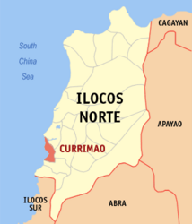
| Location of Currimao in the province of Ilocos Norte | ||
|---|---|---|

|
||
| Basic data | ||
| Region : | Ilocos region | |
| Province : | Ilocos Norte | |
| Barangays : | 23 | |
| District: | 2. District of Ilocos Norte | |
| PSGC : | 012808000 | |
| Income class : | 5th income bracket | |
| Households : | 2126 May 1, 2000 census
|
|
| Population : | 12.184 August 1, 2015 census
|
|
| Population density : | 338.4 inhabitants per km² | |
| Area : | 36 km² | |
| Coordinates : | 18 ° 1 ′ N , 120 ° 29 ′ E | |
| Mayor : | Rosario Go | |
| Geographical location in the Philippines | ||
|
|
||
Currimao is a municipality in the Philippine province of Ilocos Norte and is located on the South China Sea . In 2015, 12,184 people lived in the 36 km² area, resulting in a population density of 338 inhabitants per km². The area is relatively flat for the most part, but rises slightly inland. In addition to a lighthouse, there are rugged, but remarkable coral formations on the coast.
Currimao is in the following 23 barangays divided into:
|
|
|
