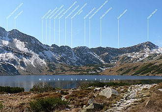
Czarna Ławka
| Czarna Ławka | |||
|---|---|---|---|
|
Pass from the mountain lake Wielki Staw Polski |
|||
| Compass direction | North | south | |
| Pass height | 1968 m npm | ||
| Podhale , Powiat Tatrzański , Lesser Poland , Poland | Slovakia | ||
| Valley locations | Bukowina Tatrzańska | Poprad | |
| Mountains | High Tatras , Tatras , Carpathians | ||
| map | |||
|
|
|||
| Coordinates | 49 ° 11 '59 " N , 20 ° 1' 46" E | ||
The Czarna Ławka (German Czarnyjoch or literally Black Bank ) is a mountain pass in the south of the Polish Voivodeship Lesser Poland and Slovakia in the High Tatras . The pass is located in the Bukowina Tatrzańska commune on the main ridge of the Tatra Mountains and connects the Dolina Pięciu Stawów Polskich with the Dolina Cicha valley . The pass is 1968 m npm high and borders the peaks of Czarna Kotelnica and Niżni Kostur .
tourism
There is no hiking trail leading to the pass.
First ascent
Baltazar Hacquet climbed the pass for the first time in 1792 .
literature
- Zofia Radwańska-Paryska, Witold Henryk Paryski, Wielka encyklopedia tatrzańska , Poronin, Wyd. Górskie, 2004, ISBN 83-7104-009-1 .
- Tatry Wysokie słowackie i polskie. Mapa turystyczna 1: 25.000, Warszawa, 2005/06, Polkart ISBN 83-87873-26-8 .
Web links
Commons : Kotelnica - collection of images, videos and audio files

