Döringsdorf
|
Döringsdorf
community Geismar
Coordinates: 51 ° 12 ′ 52 ″ N , 10 ° 9 ′ 50 ″ E
|
|
|---|---|
| Height : | 329 m above sea level NN |
| Residents : | 130 (2009) |
| Incorporation : | 1st February 1974 |
| Incorporated into: | Döringsdorf-Bebendorf |
| Postal code : | 37308 |
| Area code : | 036082 |
|
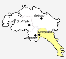
Location of Döringsdorf in Geismar
|
|
|
Döringsdorf under the Hülfensberg
|
|
Döringsdorf is a district of Geismar in the Eichsfeld district in Thuringia .
location
Döringsdorf is located directly on the state border with Hesse at the southeastern foot of the Hülfensberg , about two kilometers north of Wanfried . The next larger cities are Eschwege eight kilometers southwest and Heilbad Heiligenstadt, 18 kilometers north . The district can be reached via Kreisstraße 115 , which connects the districts around Hülfensberg with Geismar and Wanfried. The highest elevation in the district is the Keudelskuppe (484.7 m) in the extreme south of the district.
history
Döringsdorf was first mentioned in 1421 as Doringsdorff . The name reminds of the founder - During. The village was owned by Hesse and lent to the Keudell family . During the wars of 1357-1402 between the Landgraves of Hesse and Thuringia, the residents fled to Hülfensberg and settled there around the chapel. Around 1500 the villages in the area were inhabited again. At the beginning of the 16th century, Döringsdorf came to Asmus II von Buttlar through the marriage of a daughter from the Keudel family , who ceded it to Landgrave Philipp in exchange for other goods. The village came to the Hessian Wanfried Office . On September 8, 1583, the Landgraves of Hesse exchanged the village for the Archbishop of Mainz and Elector Wolfgang von Dalberg , and the village was assigned to the office of Bischofstein . For this Frieda came from the office of Bischofstein to the Hessian office of Eschwege . Döringsdorf was the last place that came to the Mainz Eichsfeld . When Walrab von Keudel died in 1792, Kurmainz moved the Keudel property in Döringsdorf as a settled fiefdom.
After the Second World War, the place was in the Soviet occupation zone and directly on the inner-German border and suffered from the associated restrictions until 1989.
Döringsdorf together with Bebendorf formed the municipality Döringsdorf / Bebendorf , which was incorporated into Geismar on January 22, 1994.
Worth seeing
In the village is the Catholic Church of St. Stephen from 1813. The varied landscape around the Hülfensberg invites you to numerous hiking destinations, including the former inner-German border and today's Green Belt . There you will find the Eichsfelder Kreuz on the way towards Wanfried . It stands on the Hessian side near the state border and was erected as a memorial in 1980 and is today a symbol of the regained German unity .
Individual evidence
- ↑ Erhard Müller: The place names of the district of Heiligenstadt. Heilbad Heiligenstadt 1989, p. 14


