Bebendorf
|
Bebendorf
community Geismar
Coordinates: 51 ° 12 ′ 49 ″ N , 10 ° 9 ′ 23 ″ E
|
|
|---|---|
| Height : | 325 m above sea level NN |
| Residents : | 130 (2009) |
| Incorporation : | 1st February 1974 |
| Incorporated into: | Döringsdorf-Bebendorf |
| Postal code : | 37308 |
| Area code : | 036082 |
|
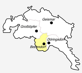
Location of Bebendorf in Geismar
|
|
|
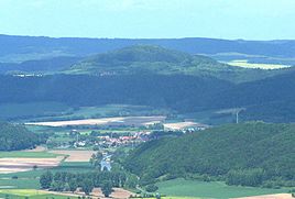
View from the southeast over Wanfried to the Hülfensberg and Bebendorf
|
|
Bebendorf is a district of Geismar in the Eichsfeld district in Thuringia .
location
Bebendorf is located directly on the state border with Hessen at the southeastern foot of the Hülfensberg . To the north behind the Hülfensberg lies Geismar, immediately to the east Döringsdorf and about two kilometers south the nearest town Wanfried in the Werra valley . Eschwege is about seven kilometers away in a south-westerly direction. The district can be reached via Kreisstraße 115 , which connects the districts around Hülfensberg with Geismar and Wanfried.
history
The village was first mentioned on February 13, 1342. In the 14th century, Bebendorf was owned by the Lords of Proyse , who pledged it to Konrad Zupich in 1352 and sold it to the Anrode monastery in 1381 . The Anrode monastery allowed the residents to use the church on the Hülfensberg. As a result, Bebendorf is one of the few villages in Eichsfeld that still does not have its own church.
In 1675 the village had 45 inhabitants. In 1787 there were 165. After the Second World War, the residents suffered from the border measures taken by the GDR on the inner-German border .
Bebendorf together with Döringsdorf formed the municipality Döringsdorf / Bebendorf , which was incorporated into Geismar on January 22, 1994. In 2009 the place had 130 inhabitants.
Web links
Individual evidence
- ^ Wolfgang Kahl : First mention of Thuringian towns and villages. A manual. Rockstuhl Verlag, Bad Langensalza, 2010, ISBN 978-3-86777-202-0 , p. 27
- ↑ Bebendorf on the website of the Ershausen-Geismar administrative association.Retrieved on June 14, 2012

