Dune du Pilat
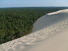
The Dune du Pilat (also Grande Dune du Pilat ) on the Atlantic coast near Arcachon ( France ) is the largest shifting dune in Europe.
It has a north-south course and is up to 110 meters high (81 meters according to SRTM data ), 500 meters wide, about 2.7 kilometers long (estimated volume 60 million cubic meters) and is located at the sea opening of the Bassin d ' Arcachon , south of the town of Arcachon and the suburb Pyla sur Mer, across from Cap Ferret . On the west side (to the sea) it has a slope of between 5 ° and 20 °, the east side drops sharply (30 ° to 40 °).
The dune has a pure sand area of 135 hectares, the surrounding forest about 4000 hectares.
As this area is of great ecological interest, it was declared a nature reserve in 1978 .
history
The sea, the wind, the currents, storms and tides, as well as humans, all contributed to the development of the dune. Their internal structure reveals their long evolution, which can be traced back over about 18,000 years. The various successive climates and vegetations can be read inside.
The sea level 18,000 years ago was 120 meters below its current level. Gravel, various types of sand and gravel were deposited on the beach at that time . When the snow and ice began to melt at the end of the last glacial period , as a result of which the sea level rose, it covered these materials. In the following period the sea left fine sediments on the coasts. Strong winds whirled them up and blew them to higher land plains. The Dune du Pilat was created by the superposition of two dune systems: Barchane and parabolic dunes .
The first fundamental research took place in 2000 when parts of the dune eroded due to wind and tides . You could see and examine four different layers:
- Gray, silicate-like , organic and iron-containing stones as well as peat , trunks and branches were found, all of which were in an excellently preserved condition. By examining the pollen , the scientists were able to determine that pines , hazel bushes, alders, birches and willows covered this swampy area. At the same height, i.e. one meter from the beach, you can see fresh water emerging. It is groundwater that flows into the ocean when the tide is low .
- The second layer is four meters above sea level. 4000 BC, strong winds carried fine sand to this forest. Some small dunes stand out. Further inland there must have been swamps and a pond.
- The third layer (20 to 40 meters) consists of parabolic dunes. They found flint tools dating back to around 1000 BC, as well as clay dishes and coins from the Middle Ages.
- The fourth layer shows the covering of the parabolic dunes with the barchans (also sickle-shaped, but the ends point to the wind). In the 18th century the port entrance to the Arcachon Basin was blocked with islands; the northwestern Cap Ferret moved slowly more than 4000 meters to the south, which contributed to the fact that the dune was able to form as it is today.
At the end of the 18th and beginning of the 19th century it was the extension to the south of Cap Ferret, the simultaneous relocation of the Banc d'Arguin to the southeast, which connected the Arcachon basin with the ocean. This increased the rate of coastal erosion from the waves and tides, releasing large amounts of sand that were picked up by the westerly winds and helped create the great rod-shaped dune known as "de la grave". The ocean current eroded the course of the coast and made the amounts of sand available that covered the parabolic dunes. At the end of the 19th century, the height of the dune was 80 meters.
The strong winds continued to transport eroded sand cubic meters to the dune, increasing it to 118 meters and driving it eastwards at different speeds (between one and five meters per year).
Nowadays the amount of sand carried by the wind is less, so the dune is losing height; but the tides, the erosion and the wind contribute to the creation of a new dune further south at the level of the Petit-Nice campsite.
In 1994 the municipality of La Teste-de-Buch decided to stabilize the northern part of the dune. The profile of the dune was changed with bulldozers , small picket fences were erected and species of gorse , shrubs and pines were planted . After five years it became clear that this project was a success. The vegetation had strengthened the dune on the northern part and stopped them on their way to the houses.
In contrast, a lot of sand gets to the southern part. The dune is very active. A breach arose through which the wind whistled and destroyed the fences that were erected in 1994. There the dune continues to devour the forest behind it unhindered.
tourism
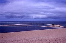
Today well over a million tourists visit the dune every year . This makes it the natural monument with the second most visitors in France, after Mont-Saint-Michel in Normandy . On the steep eastern flank you can climb through the deep sand to the summit ridge, as well as via a staircase at the northeast corner. The base of the dune is largely covered by pine forest. The tourist attraction is accessible from the rear with parking lots and three directly adjacent campsites. The view from the dune over the Arcachon basin, the Lège-Cap-Ferret peninsula with the Atlantic Ocean beyond and the vast maritime pine forests of the Landes de Gascogne is worth the climb. There are many paragliding and hang-gliding pilots on the slope facing the sea . In 2013, after a 3 year break, the Wagas Festival took place again on the dune. Paragliding acrobatics are flown close to the ground, often touching the ground.
Bunker system
On the northern side of the Dune du Pilat there are air raid shelters of the former German 286th naval artillery system, which was built on the dune around 1944. Over the years they have slipped or become increasingly covered with sand. To the south of the dune, several bunkers are already completely under the water surface.
Web links
Individual evidence
- ↑ All Pilat or what? - As the dune is called correctly. In: Dune du Pilat - Pyla sur Mer. 2011. From DuneDuPilat.com, accessed February 10, 2019.
- ↑ Whaxt's the Wagas Festival? ( Memento from June 10, 2013 in the Internet Archive )
- ↑ Louise Poupin: Les blockhaus de la dune du Pilat livrent leurs secrets. Retrieved March 3, 2020 (French).
Coordinates: 44 ° 35 ′ N , 1 ° 13 ′ W


