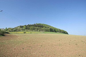
Damil
| Damil | ||
|---|---|---|
|
Damil from the east |
||
| height | 396 m nm | |
| location | Středočeský kraj , Czech Republic | |
| Mountains | Brdská vrchovina | |
| Coordinates | 49 ° 56 '54 " N , 14 ° 5' 25" E | |
|
|
||
| Type | Ridges | |
| rock | limestone | |
| Age of the rock | Devon | |
The Damil (also outdated: Daměl ) is a mountain in the Bohemian Karst near Tetín in the Czech Republic . On the summit there is a stone age fortress, of which some moats and ramparts have been preserved. Until the 1960s, the mountain was a center of limestone mining.
Location and surroundings
The mountain rises in the west of the Bohemian Karst, about two kilometers southeast of Beroun . To the east, directly on the shoulder of the mountain, is the municipality of Tetín , to the north the Beroun districts of Zavadilka and Jarov. It is surrounded by the Litavka to the northeast and the Berounka to the east .
Neighboring mountains are Kosov in the southwest and (beyond the Litavka) Děd in the northwest.
history
Lime has been quarried on Damil since the Middle Ages . The material was used, for example, to build the town hall in Beroun and the Theresienstadt fortress .
On May 9, 1898, the Kleinbahn Königshof – Beraun – Koněprus (Drobná dráha Králův Dvůr – Beroun – Koněprusy) began operations. This marked the beginning of the industrial mining of lime for cement production . The oldest such breaks were the Bílý lom ("White Break") of the Königshofer Zementfabrik AG (Královodvorská cementárna) on the west side and the Hergetův lom of the Max Herget cement factory on the east side. More breaks were added later. The largest of them were later opened up by the municipality of Tetín Modrý Lom ("Blue Break") and the Nový Bílý lom ("New White Break") of the Königshofer cement factory on the southwest side. After the narrow-gauge railway was closed in 1962, funding there came to a standstill. The Modrý Lom is now used as a motocross track .
Paths to the summit
A blue marked hiking route leads to the summit of Damil, starting in the municipality of Tetín.
Web links
Individual evidence
- ↑ Michal Martinek, Bohuslav Zeman, Radim Šnábl, Vlastimil Novotný: KBK Malodráha Králův Dvůr - Beroun - Koněprusy 1897 - 1962 ; Stopou dějin našich traťi - 2; KHKD Nymburk, 1987


