Dam (Dummerstorf)
|
dam
Dummerstorf municipality
Coordinates: 54 ° 0 ′ 34 ″ N , 12 ° 9 ′ 9 ″ E
|
|
|---|---|
| Height : | 24 m above sea level NN |
| Area : | 16.52 km² |
| Residents : | 652 (Dec. 31, 2007) |
| Population density : | 39 inhabitants / km² |
| Incorporation : | June 7, 2009 |
| Postal code : | 18196 |
| Area code : | 038208 |
Since June 7, 2009, Damm has been part of the municipality of Dummerstorf in the Rostock district in Mecklenburg-Western Pomerania (Germany).
geography
Damm is about ten kilometers south of Rostock . The district stretches along the east bank of the lower Warnow . The Warnow Valley is designated as a nature reserve together with the Zarnow, which flows into the west of Reez .
The formerly independent municipality of Damm, since 2010 a district of the municipality of Dummerstorf in the Rostock district (LRO) founded in 2011, included the districts of Groß Viegel, Klein Viegel and Reez.
history
At the beginning of the era, a Germanic clan lived between Reez and Groß Viegel at the Pressenteich, which, during the migration period, probably moved south around 400. Around 850, Slavic ethnic groups are named in the Bavarian Geographer , including the Warnower . This was divided into four groups: the Redarians, Tollensians, Zirzipans and the Kessiner.
In 1171 Heinrich the Lion of Saxony declared the Zarnow as a border river to the Principality of Werle (near Schwaan). The "Villa Damme" (= place on the river dam) was first mentioned in 1227. The place name probably comes from this. Another explanation could be the old Slavic word "dabu", which means something like "oak". In 1277 the German name "Damm" was mentioned for the first time. The reason was a land sale of six Hufen (= yards) by the Prince of Werle to the monastery "Zum Heiligen Kreuz" in Rostock. In a Rostock combing invoice, the place Reez was mentioned for the first time in 1283 (interpretation: Reez = place where speeches are held, or grain). Prince Nicholas III. zu Werle left in 1353 the monastery "Zum Heiligen Kreuz" in Rostock jurisdiction and Bede (state tax) of dam and other monastery villages.
Duke Heinrich IV of Mecklenburg inherited Reez in 1436. The Reez chapel was first mentioned in a document in 1541. Through those of the Preen Reez became a manor in 1576. During the Thirty Years War , destruction by Swedish troops also took place in Damm. In 1770, Count von Flotow had the chapel, which collapsed in 1742, renovated.
Carl Christoph Graf von Bassewitz acquired Reez in 1817, and from 1824 to 1835 many farm buildings, the estate and the village street were built. In 1838 the Plessen family bought the property. A village school was built in Reez in 1866 and in Damm in 1880. In 1927 Damm was connected to the power grid. Auguste von Plessen set up a harvest kindergarten in Reez and ten years later an electrical network was also installed here, in 1939 also in Groß Viegel. In 1942, bombed-out Rostock families found refuge in Reez. On May 1, 1945 the Red Army reached Reez, the manor was declared a commandant's office, and the following day Polish riders took Groß Viegel. In October 1945 there was a land reform, new farmer positions were created. In 1946 the Red Army left the community and the Association of Mutual Farmers Aid (VdgB) was founded. Three years later the Damm – Reez volunteer fire department was founded. The LPG "Neues Deutschland Damm" (Agricultural Production Cooperative) was founded in 1953 and in 1969 the drinking water network was completed in the entire community.
On July 1, 1950, the previously independent municipality of Reez was incorporated.
Attractions
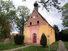
- Smithy , manor house and chapel (built around 1800 in classicist style) in the Reez district
- Horse stud farm (riding tourism) in the Groß Viegel district, see also Sport in Dummerstorf
Transport links
Damm is in close proximity to the Rostock junction ( A 19 / A 20 ), the Kavelstorf exit is 2.5 kilometers from Damm. There is a rail link in nearby Kavelstorf (Rostock-Berlin route).


