Daniell Peninsula
| Daniell Peninsula | ||
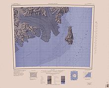
 Topographic map of the Daniell Peninsula (bottom center, incomplete) |
||
| Geographical location | ||
|
|
||
| Coordinates | 72 ° 50 ′ 0 ″ S , 169 ° 35 ′ 0 ″ E | |
| location | Borchgrevink Coast , Victoria Land , East Antarctica | |
| Waters 1 | Ross Sea | |
| Waters 2 | Whitehall Glacier and Tucker Inlet | |
The Daniell Peninsula is a large peninsula on the Borchgrevink coast of the East Antarctic Victoria Land . It extends from Cape Daniell in the north to Cape Jones at its southern end. Similar to the Adare Peninsula and the Hallett Peninsula , it corresponds to an elongated basalt dome up to 2000 m high. The Whitehall Glacier separates most of the peninsula from the Victory Mountains , which it connects to near Mount Prior .
Participants in a campaign of the New Zealand Geological Survey Antarctic Expedition (1957-1958) named them based on the naming of Cape Daniell after the British physical chemist John Frederic Daniell (1790-1845), lecturer at King's College London .
Web links
- Daniell Peninsula in the Geographic Names Information System of the United States Geological Survey (English)
- Daniell Peninsula on geographic.org (English)

Map sheet Coulman Island from 1967: Southern part of the Daniell Peninsula in the middle of the northern edge of the map
