Dargol (river)
| Dargol | ||
|
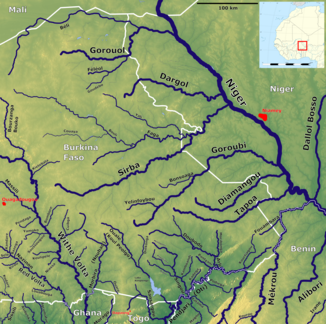
The Dargol (top center) |
||
| Data | ||
| location | Sahel region in Burkina Faso and Tillabéri region in Niger |
|
| River system | Niger | |
| Drain over | Niger → Atlantic | |
| origin | at Dori 14 ° 0 ′ 11 ″ N , 0 ° 10 ′ 17 ″ E |
|
| muzzle | near Gothèye in the Niger Coordinates: 13 ° 53 ′ 4 " N , 1 ° 32 ′ 39" E 13 ° 53 ′ 4 " N , 1 ° 32 ′ 39" E
|
|
| length | 212 km | |
| Catchment area | 7200 km² | |
| Discharge at the Kakassi gauge (1234120) A Eo : 6940 km² |
MNQ 1957-1967 MQ 1957-1967 Mq 1957-1967 MHQ 1957-1967 |
0 l / s 1.1 m³ / s 0.2 l / (s km²) 5.6 m³ / s |
| Right tributaries | Tilim | |
| Flowing lakes | Mare d'Ossolo | |
| Reservoirs flowed through | Téra dam | |
| Medium-sized cities | Téra | |
The Dargol is a tributary of the Niger in the states of Burkina Faso and Niger .
course
The Dargol rises in Burkina Faso east of the city of Dori . From there it flows eastwards over the state border with Niger. It flows through the Mare d'Ossolo and is dammed in front of the city of Téra by the Téra dam, which was completed in 1980 . The reservoir is used for irrigation , water supply and livestock farming . About 20 km after Téra, the 77 km long Tilim flows into the Dargol as the most important of the small tributaries. Larger villages on the further course of the river are Bandio , Garbougna , Kossogo , the Dargol of the same name , Bangou Tara , Guériel , Dartchandé and Koulikoira . The Dargol flows into the Niger north of the village of Gothèye .
The river has a total length of 212 km and a catchment area of 7200 km². The river basin is on average 257 m above sea level, with a range from 200 to 320 m. In its middle reaches the Dargol has a gradient of 35 cm / km, which increases in the lower reaches to 55 cm / km.
Hydrometry
The estimated average annual flow rate at the measuring station in Kakassi was 160 million m³ from 1957 to 1978 and 173 million m³ from 1978 to 2001. In general, the water flow of the Dargol and its usually dry tributaries increases during the annual rainy season, which lasts around two to three months.
Average monthly flow through the Dargol measured at the hydrological station near Kakassi in m³ / s.

geology
In geological terms, the Dargol is characterized by granite with partly Precambrian overburden. The landscape is rugged. Aeolian sediments are mainly found in the lower reaches.
literature
- Maman Sani Abdou Babaye: Evaluation of the resources en eau souterraine dans le bassin de Dargol (Liptako - Niger) . Thèse de doctorat. Université de Liège, Liège 2012 ( orbi.uliege.be [PDF]).
Individual evidence
- ↑ a b c d e Y. Brunet-Moret, P. Chaperon, JP Lamagat, M. Molinier: Monographie hydrologique du fleuve Niger . Tome II: Cuvette Lacustre et Niger Moyen. Orstom, Paris 1986, ISBN 2-7099-0790-9 , pp. 260 ( hydrosciences.fr [PDF; accessed September 25, 2018]).
- ↑ a b Monograph Hydrologique du Bassin du Niger - 1ère Partie le Niger Superieur et le Bani
- ↑ Lawrence Rupley, Lamissa Bangali, Boureima Diamitani: Historical Dictionary of Burkina Faso . 3. Edition. Scarecrow, Lanham / Toronto / Plymouth 2013, ISBN 978-0-8108-6770-3 , pp. 54 .
- ↑ Mare d'Ossolo on the website of the UNESCO World Heritage Center on tentative lists (French). Retrieved March 2, 2019.
- ^ Dams of Africa. (xlsx) Food and Agriculture Organization of the United Nations (FAO), accessed on September 23, 2018 .
- ^ Y. Brunet-Moret, P. Chaperon, JP Lamagat, M. Molinier: Monographie hydrologique du fleuve Niger . Tome II: Cuvette Lacustre et Niger Moyen. Orstom, Paris 1986, ISBN 2-7099-0790-9 , pp. 276 ( hydrosciences.fr [PDF; accessed September 25, 2018]).
- ^ H. Hassane Seyni, B. Ousmane, I. Soumana, B. Yamba: Impacts des activités socio-économiques sur les ressources en eau du barrage de Téra au Niger . In: Afrique Science . Vol. 10, No. 2 , 2014, ISSN 1813-548X , p. 151–152 ( ajol.info [PDF; accessed September 23, 2018]).
