
Bangou Tara
Location of Bangou Tara in Niger |

Bangou Tara (also: Bangoutara , Bangoutéra ) is a village in the rural community of Dargol in Niger .
The village, run by a traditional chief ( chef traditionnel ), is located around 14 kilometers southeast of Dargol, the capital of the rural community of the same name, which belongs to the Gothèye department in the Tillabéri region. Bangou Tara is located on the left bank of the Dargol River . The larger villages in the area include Guériel in the south and Dartchandé in the east.
Bangou Tara was one of those places in present-day Niger where Songhai refugees settled under descendants of the Askiya dynasty after the fall of the Songha Empire in 1591 .
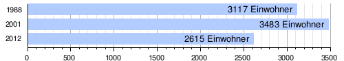
At the 2012 census, Bangou Tara had 2,615 residents who lived in 404 households. At the 2001 census, the population was 3,483 in 426 households, and at the 1988 census, the population was 3,117 in 409 households.
National road 4 runs through the village . There is a weekly market in Bangou Tara. The market day is Saturday. A health center with a maternity ward is available to the population.
Individual evidence
- ↑ a b National Repertoire des Localités (ReNaLoc). (RAR) Institut National de la Statistique de la République du Niger, July 2014, p. 441 , accessed on 7 August 2015 (French).
- ↑ Edmond Séré de Rivières: Histoire du Niger . Berger-Levrault, Paris 1965, p. 74 .
- ^ Répertoire National des Communes (RENACOM). (RAR file) Institut National de la Statistique, accessed November 8, 2010 (French).
- ↑ Recensement Général de la Population 1988: Répertoire National des Villages du Niger . Bureau Central de Recensement, Ministère du Plan, République du Niger, Niamey March 1991, p. 261 ( ceped.org [PDF; accessed January 31, 2018]). www.ceped.org ( Memento of the original dated January 31, 2018 in the Internet Archive ) Info: The archive link was inserted automatically and has not yet been checked. Please check the original and archive link according to the instructions and then remove this notice.
- ↑ Issa Abdou Yonlihinza: Transports et dans la désenclavement problématique du développement local à Téra au Niger . Thèse de doctorat. Université Toulouse 2 Le Mirail, Toulouse 2011, p. 242 ( tel.archives-ouvertes.fr [PDF; accessed October 29, 2018]).
- ^ Niger DSS. In: Systems Nationale d'Information Sanitaire (SNIS). Ministère de la Santé Publique, République du Niger, accessed on November 3, 2018 (French).
Coordinates: 13 ° 51 ' N , 1 ° 21' E