Dehri
| Dehri डेहरी आन सोन |
||
|---|---|---|
|
|
||
| State : |
|
|
| State : | Bihar | |
| District : | Rohtas | |
| Location : | 24 ° 55 ' N , 84 ° 11' E | |
| Height : | 110 m | |
| Area : | 21.32 km² | |
| Residents : | 137,231 (2011) | |
| Population density : | 6437 inhabitants / km² | |
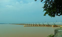
| Indrapuri barrage near Dehri | ||
Dehri or Dehri-on-Sone ( Hindi : डेहरी आन सोन) is a former industrial city with around 150,000 inhabitants in the Indian state of Bihar .
location
Dehri is located in the southwest of Bihar approx. 154 km (driving distance) southwest of the city of Patna on the river Son in the Ganges plane near the Grand Trunk Road at an altitude of approx. 110 m above sea level. d. M .; the district capital Sasaram is about 20 km to the west. The climate is mostly hot and dry; Rain (approx. 1200 mm / year) almost only falls in the summer monsoon months .
population
Official population statistics have only been kept and published since 1991.
| year | 1991 | 2001 | 2011 |
| Residents | 93,694 | 119.057 | 137.231 |
A good 83.5% of the majority of the Bhojpuri , Hindi and Urdu- speaking population are Hindus , around 15.5% are Muslims ; Sikhs , Buddhists , Jains and Christians etc. are numerically small minorities. The male population clearly exceeds the female population.
economy
The sister city of Dalmianagar, founded after 1900, was an industrial city. In the 1980s, however, many businesses had to close due to unprofitability and infiltration by Mafia-like circles. Dehri is important from a traffic point of view, as both a road and a railway bridge cross the Son River, which is no more than 3 km wide, but which in the spring almost dried up. About 10 km southwest of the city, a barrage ( Indrapuri-Dam ) was built in the 1960s , which is primarily used for irrigation purposes.
history
In the 6th and 5th centuries BC The Magadha dynasty resided in the region . Little is known about Dehri's medieval history. Around the year 1486, Sher Khan Suri was born in the neighboring town of Sasaram . In the years after 1531 he succeeded in bringing large parts of Bihar and Bengal under his control. He tightened and reorganized the Mughal Empire and had large parts of the later Grand Trunk Road laid out and fortified. After his death, the city fell largely insignificant for centuries. The British took control in the 19th century .
The Dehri Rohtas Light Railway operated here from 1907 to 1984 .
Attractions
Dehri has no sights of historical or cultural importance.
- Surroundings
- In the neighboring town of Sasaram , about 20 km to the west, there are two impressive mausoleums of the Surid dynasty.
- Approx. The impressive Rohtasgarh fortress is located 60 km to the southwest on a mountain plateau above the Son River . Behind an imposing gate ( Hathiya-Pol ) lie the ruins of a palace complex built by Maharaja Man Singh I at the end of the 16th century. One and a half kilometers northeast are the ruins are the remains of three religious buildings ( Ganesh Temple , Rohtasan Temple and Devi Temple ).
Web links
- Dehri - Info (English)

