Monuments to the Warsaw Ghetto
The monuments to the Warsaw Ghetto are 22 memorial sites (in the form of memorial plaques and plaques), which mark the course of the border wall of the Warsaw Ghetto in the districts of Wola and Śródmieście (German: Stadtmitte ).
Today the monuments are reminiscent of the furthest border points of the former separate Jewish residential area in Warsaw. Where in the years 1940–1943 a. a. the gates to the ghetto, the wooden bridges over the streets on the Aryan side of the city and important buildings for the ghetto residents, the memorials were erected.
History and project of the monuments
In order to preserve the memory of the Jewish quarter, the Jewish Historical Institute (pol. Żydowski Instytut Historyczny , ŻIH for short ) and the City of Warsaw Monument Protection Office ( Stołeczny Konserwator Zabytków ) have taken the initiative, the important ones in the public space of the Polish capital To mark memorial sites on the former borders. The project was developed by Eleonora Bergman and Tomasz Lec in collaboration with Ewa Pustoła-Kozłowska (responsible for the distribution of the monuments) and Jan Jagielski (responsible for the historical information on the plaques and plaques and for the selection of the photos).
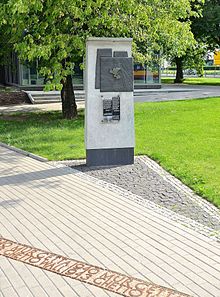
Each monument consists of three parts:
- from a bronze plaque measuring 60 × 70 cm, on which the map with the furthest border points of the ghetto, the pre-war road network on a map of Warsaw and the pin indicating the exact location of the marked memorial are displayed
- from an acrylic sheet measuring 36 × 50 cm with brief information in Polish and English about the place, its role in the history of the ghetto, two or three archive photos and a brief history of the Warsaw ghetto:
“By order of the German occupation authorities, the ghetto was separated from the city on November 16, 1940. The area surrounded by a wall was initially 307 hectares, then it was reduced in size. From January 1942, the Jewish quarter was divided into two parts, the so-called large and small ghetto. About 360,000 Jews from Warsaw and 90,000 more from other places were locked in the ghetto. Around 100,000 people starved to death. In the summer of 1942 , the Germans deported and murdered almost 300,000 people in the Treblinka gas chambers . On April 19, 1943, the ghetto uprising broke out . By mid-May, fighters and civilians were killed in combat and in the flames of the ghetto, which was systematically set on fire. Those who were still alive were murdered by the Germans in November 1943 in the Majdanek , Poniatowa and Trawniki concentration camps . Few survived.
In memory of those who have suffered, fought and perished.
The city of Warsaw, 2008. "
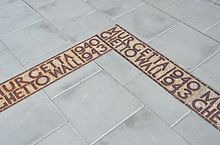
- made of concrete slabs with a width of 25 cm with a bilingual inscription made of cast iron MUR GETTA 1940 / GHETTO WALL 1943 (German: GHETTOMAUER ), which are on the footpaths or lawn and indicate the exact location of the ghetto wall . The dates 1940–1943 have a symbolic meaning and refer to the years of existence of the Warsaw Ghetto. Most of the marked locations were excluded from the ghetto in 1941–1942; one was admitted in December 1941 and two more in January 1942.
Fourteen boards were placed on the specially constructed concrete pillars with a height of 230 cm and placed on a paving stone, further boards are located directly on the walls and walls of buildings.
The memorials opened between April and November 2008. Initially, after the project, 21 monuments were planned. The twenty-second plaque was unveiled on January 27, 2010 at the International Holocaust Remembrance Day celebrations on the preserved part of the ghetto wall on Sienna Street.
The project was funded by the City of Warsaw and the Ministry of Culture and National Heritage ( Ministerstwo Kultury i Dziedzictwa Narodowego , abbreviated MKiDN ).
Locations of the monuments
-
General - Władysław Anders Street, on the corner of Świętojerska Street - the memorial commemorates one of the main gates to the ghetto, which was located on the former Nalewki Street. Through this gate at 5:30 a.m. on April 19, 1943, the German troops entered the ghetto in cooperation with the Latvian and Ukrainian troops under Ferdinand von Sammern-Frankenegg and met the armed resistance of the Jewish fighters. These fights sparked the Warsaw Ghetto uprising .
- on Bielańska Street, on the corner of Antoniego Corazziego Street - here was the Great Synagogue of Warsaw on Tłomackie Street ( Wielka Synagoga na Tłomackiem ) and the Main Library of Judaic Studies (Główna Biblioteka Judaistyczna ). This part of the Śródmieście district was excluded from the ghetto on March 20, 1942.
- Bonifraterska Street, near Międzyparkowa Street - at the intersection of Bonifraterska and Żoliborska Streets was the northeast corner of the ghetto. Over Przebieg Street, the northern part of which was excluded from the ghetto, there was a wooden bridge - one of the four footpaths of this type that were built in the Warsaw ghetto by order of the Germans.
- Chłodna Street, on the corner of Elektoralna Street - this memorial is reminiscent of the building of the Warsaw Regional Court on Leszno Street ( Sądy Grodzkie na Lesznie (then); today Sąd Okręgowy w Warszawie in Solidarności Avenue), that wasn't part of the ghetto. The courthouse was a meeting place for people from both sides of the ghetto wall and, until 1942, one of the main points of escape for Jews to the Aryan side of Warsaw. After the war, Biała Street, which led from the south to the courthouse (from the Aryan side of the ghetto), was rebuilt about 200 meters to the west.
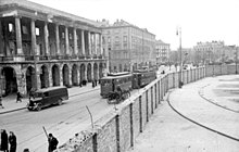
- Chłodna Street, near Żelazna Street - the memorial commemorates the area delimited by Leszno, Wronia, Grzybowska and Żelazna Streets and excluded from the ghetto in December 1941, dividing the Jewish Quarter into two parts was shared. This is how the large and small ghetto came into being. One of the symbols of the Holocaust was also located here : the wooden bridge over Chłodna Street, which was open to the residents of the ghetto from January 26, 1942.
- 41 Chłodna Street - until December 1941 the western border of the ghetto ran along the back of the properties in Wronia Street. One of the first gates to the ghetto was also located here (open until November 1941). In December 1941, this part of the Wola district was excluded from the Jewish quarter and its border was moved to the center of Żelazna Street.
- Defilad Platz 1, on the eastern wall of the northeast corner of the Palace of Culture and Science ( Pałac Kultury i Nauki) with the Theater Studio ( Teatr Studio ) - the southeastern border of the ghetto ran between the properties. On October 5, 1941, the ghetto border was moved to the middle of Sienna Street.
- Piotra Drzewieckiego Avenue on Żelaznej Bramy Square - from here to the west to Żelazna Street was an area that was not included in the ghetto. It included the Mirowska Market Hall ( Hala Mirowska ), Mirowskie Barracks ( Koszary Mirowskie ) and the Church of St. Charles Borromeo ( Kościół św. Karola Boromeusza ). Chłodna Street was an important east-west transportation route and formed a corridor that divided the ghetto into two parts.
- Piotra Drzewieckiego Street, near Jana Pawła II avenue - the memorial plaques were placed on the south wall of the “Hala Mirowska” shopping mall. They are reminiscent of the northern border of the Small Ghetto, which ran along the border wall between the properties.
- Dzika Street, near Jana Pawła II Avenue - this is where the northwest corner of the ghetto was after the border of the separate Jewish quarter was moved a little north to Dzika Street in January 1942.
- Dzika Street, on the corner of Stawki Street - the memorial commemorates the gate that led to Umschlagplatz from January 1942 .
- 55 Freta Street (from the Franciszkańska Street side) - this was the easternmost part of the Jewish Quarter. The entire area of the Nowe Miasto (German: Neustadt ) district was excluded from the ghetto in December 1941.
-
Młynarska Street, by the wall of the Jewish cemetery (next to the border of the cemetery with the Caucasian Islamic Cemetery - Muzułmański Cmentarz Kaukaski ) - this place reminds of the Jewish cemetery, the wall of which is along Młynarska Street and Powązki Cemetery ( Cmentarz Powązkowski ) determined the north-western boundary of the separate quarter. This is how the border of the Jewish cemetery ran until its exclusion from the ghetto in December 1941.
- 49/51 Okopowa Street, along the wall of the Jewish Cemetery (from the Mordechaya Anielewicza Street side) - this is the second memorial of the largest Jewish necropolis in Warsaw and the Skra Sports Club stadium adjoining it from the south. The stadium was the only major undeveloped area in the ghetto. It became a place of individual and group trenches and executions, as the nearby memorial of the Common Martyrdom of Jews and Poles commemorates. This is also where the fallen of the Warsaw Uprising were buried.
- Sienna Street 53 (today the schoolyard of the Henryk-Sienkiewicz-Liceum) - the memorial of the ghetto border from the Aryan side, which stood on the existing wall between the properties in Sienna Street 53 and 55. The southern border of the Jewish quarter was moved to the middle of Sienna Street on October 5, 1941.
-
The "Solidarności" avenue between the building (No. 76b) of the Warsaw Chamber Opera ( Warszawska Opera Kameralna ) and the building (No. 76a) of the so-called House of Dissidents ( Dom Dysydentów ), where the seat of the Evangelical Church is located Reformed Church ( Kościół Ewangelicko-Reformowany ) - the memorial commemorates the so-called Evangelical Enclave that was excluded from the ghetto together with the Church, the House of Dissidents, the Działyński Palace ( Pałac Działyńskich ), the Evangelical Hospital ( Szpital Ewangelicki ) and some buildings in the former Mylna Street. The enclave was walled on all sides and connected to the Aryan quarter by a narrow passage on the eastern side, on the site of a plot of land destroyed in September 1939 at 5. Przejazd Street. This particular location made it easier for the parishioners and the clergy helping Jews in the ghetto.
- Stawki Street, near Okopowa Street - this is where the ghetto border ran along the southern wall of the Temler & Szwede tannery ( Fabryka Garbarska Temler i Szwede ) at 78 Okopowa Street, which was not included in the ghetto.
- Świętojerska Street, on the corner of Nowiniarska Street - here is the only preserved part of the wall surrounding the northern area of the ghetto.
- Świętokrzyska Street, on Major Bolesław Kontrym “Żmudzin” Square ( Skwer mjr. Bolesława Kontryma “Żmudzina” ) - the eastern border of the southern part of the separate Jewish quarter ran between the properties. In March 1941 the ghetto wall was moved west to Bagno Street.
- Twarda Street, on the corner of Złota Street - this is where the southwest corner of the ghetto was and one of the first gates to the ghetto, which was open from November 16, 1940 to January 20, 1941.
- 63 Żelazna Street on the building of the “Duschik and Szolce” Hardware Factory ( Fabryka Wyrobów Żelaznych “Duschik i Szolce” ) from the Grzybowska Street side - one of the main gates to the Small Ghetto was located here.
- Żelazna Street, on the corner of Solidarności avenue - on the wall of the pre-war building of primary schools ( called szkoła powszechna until the educational reform after World War II , later converted to szkoła podstawowa) nos. 10, 17, 56 and 119 at the 88 Żelazna Street (today the Wola District Office in Solidarności Street 90) are memorial plaques reminding of one of the main gates to the ghetto at the intersection of Żelazna Street and former Leszno Street The building of the Collegium Secondary School Community ( Towarzystwo Szkoły Średniej “Collegium” ) at 84 Leszno Street, which was incorporated into the ghetto in April 1941 , is where the Department of Labor and Statistics of the Judenrat ( Wydział Pracy i Wydział Statystyczny Rady Żydowskiej ). The building was an enclave of the ghetto on the Aryan side. In September 1941 it was connected to the separate Jewish quarter by a wooden bridge that was built on the first floor over the ghetto wall in the middle of Żelazna Street.
Footnotes
- ^ Linia pamięci. In: Stolica. 4/2008, p. 23. ISSN 0039-1689
- ↑ Inauguracja projektu Upamiętnienia Granic Getta Warszawskiego | Warsaw - oficjalny portal stolicy Polski. Retrieved June 3, 2018 .
- ↑ Uciekła z getta, teraz odsłoniła tablicę . In: Życie Warszawy . ( com.pl [accessed June 3, 2018]).
- ↑ Wyborcza.pl. Retrieved June 3, 2018 .
- ^ Bernard Mark: Walka i zagłada warszawskiego getta. Wydawnictwo Ministerstwa Obrony Narodowej, Warszawa 1959, p. 257.
- ^ The three other wooden bridges were located above Mławska Street, at the intersection of Żelazna and Leszno Streets, and above Chłodna Street, on the corner of Żelazna Street. See: Barbara Engelking, Jacek Leociak: Getto warszawskie - przewodnik po nieistniejącym mieście. IFiS PAN publishing house, Warsaw 2001, ISBN 83-87632-83-X , p. 121 (Polish).
- ↑ Joanna Nalewajko-Kulikov: Strategy przetrwania: Żydzi po stronie aryjskiej Warszawy . Wydawn. "Neriton", Warszawa 2004, ISBN 83-8897380-0 .
- ^ Marian Fuks, Mazal Holocaust Collection: Adama Czerniakowa Dziennik getta warszawskiego: 6. IX. 1939-23. VII. 1942 . 1st edition. Państwowe Wydawn Nauk, Warszawa 1983, ISBN 83-01-05094-2 .
- ↑ Jacek Leociak: Spojrzenia na warszawskie getto . 1st edition. Warszawa 2011, ISBN 978-83-62020-26-3 .
- ↑ Barbara Stahlowa: Parafia Ewangelicko-Reformowana w Warszawie (informer). Parafia Ewangelicko-Reformowana w Warszawie, Warszawa 2009, p. 3.
- ↑ Michał Krasucki: Warszawskie dziedzictwo postindustrialne . 1st edition. Fundacja "Hereditas", Warszawa 2011, ISBN 978-83-931723-5-1 .
- ↑ Kapela Praska (Musical group): Warszawa między wojnami: opowieść o życiu stolicy 1918-1939 . 1st edition. Księży Młyn Dom Wydawniczy, Łódź 2009, ISBN 978-83-61253-51-8 .
- ↑ Jacek Leociak: Spojrzenia na warszawskie getto . 1st edition. Warszawa 2011, ISBN 978-83-62020-26-3 .


