Ahuachapán Department
| Ahuachapán | |
|---|---|
| Location of Ahuachapán in El Salvador | |
| Data | |
| Capital | Ahuachapán |
| population | 363,500 (Ber. 2017) |
| surface | 1,240 km² |
| Population density | 295 inhabitants / km² |
| structure | 12 |
| ISO 3166-2 | SV-AH |
| Website | Amss.gob.sv |
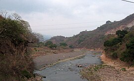
| The Río Paz is the border river between El Salvador and Guatemala | |
Ahuachapán is one of 14 departments in El Salvador . The capital of the department is the city of the same name, Ahuachapán .
location
The Ahuachapán Department is located in the far west of the country on the border with Guatemala; the Río Paz forms the border. The capital of the country, San Salvador , is about 100 km (driving distance) away.
history
The department was founded on February 9, 1869 during the tenure of Francisco Dueñas , the first President of El Salvador.
economy
The main economic factors in Ahuachapán are the cultivation of coffee , beans and sugar cane . There is also a geothermal power plant and two smaller hydropower plants in the administrative area . Tourism plays a rather insignificant role on the beaches of the Pacific coast .
Municipios
The department of Ahuachapán is in turn divided into twelve municipalities :
Attractions
- The pre-Columbian city of Cara Sucia is located in the southwest of the department and is assigned to the Cotzumalhuapa culture .
- The densely wooded Parque Nacional El Imposible National Park, created in 1989, is located about 20 km northeast of Cara Sucia.
- Some colonial church buildings are also of cultural and historical importance.
Web links
- http://www.amss.gob.sv/pages/municipios/ahuachapan.htm
- http://www.4elsalvador.com/departamento_de_ahuachapan.htm
Coordinates: 13 ° 54 ' N , 89 ° 48' W


