
Dernberg
| Dernberg | ||
|---|---|---|
 The local mountain seen from the northeast |
||
| Alternative name (s): | Ternberg, Dirnberg, Tennberg, Haslach | |
| Castle type : | Local mountain | |
| Conservation status: | Very well-preserved and easily surveyable, monumental house mountain complex. | |
| Place: | Nappersdorf-Kammersdorf | |
| Geographical location | 48 ° 37 '3.2 " N , 16 ° 10' 39.4" E | |
| Height: | 281 m above sea level A. | |
|
||

The Dernberg is a former local mountain in the municipality of Nappersdorf-Kammersdorf in the Hollabrunn district in Lower Austria . Today it is home to dry grasslands of national importance.
Geography and geology
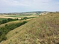
The former local mountain lies between the villages of Nappersdorf , Haslach , Aschendorf / Hart and Oberstinkenbrunn in an intensively arable landscape. While the terrain is flat in the north of the north-south ridge, it drops around 26 meters in the west and south and 12 to 18 meters in the east. To the west of the Dernberg rises a stream that carries water at times and runs north. The soils of the Dernberg consist of loess and quartz gravel .
Description of the structure
The object, which is oriented in north-south direction, has overall dimensions of around 180 × 140 meters. The earthworks in the center consists of a huge core in the form of an 8 to 9 meter high truncated pyramid , which sits on a partially walled, trapezoidal base. The top surface of the truncated pyramid has an approximately triangular shape, with the tip facing south. The northern side of the triangle is around 20 meters long, the height of the triangle is around 46 meters. The flanks of the truncated pyramid slope steeply on all sides. Due to the evenness of the slopes, it seems natural to think of an artificial over-shaping or steepening. In the north, where the terrain is flat and therefore attacks were the most promising, the structure was heavily walled and the remains of it are still clearly visible. The shield wall was separated from the core work by a mighty neck ditch and provided with a broad, sloping crown. Outside there is a 16 meter wide berm , which is closed off by a 3 meter high embankment. To the west and east, the shield wall merged into an edge wall, which probably enclosed the structure on all sides. In the northeast, the shape of the terrain suggests a Vorwerk and this is where the former entrance to the fortress can be assumed. In the south, the terrace in front of the core plant is significantly wider and forms a slightly raised area around 40 meters in diameter. This area seems to have been suitable as a location for a former development. Due to its size and height, the good state of preservation, the remote location and the low vegetation cover, the building is one of the most remarkable structures of its kind in the district.
nature
Due to the steep ditches and embankments and the dryness of the towering earthwork, the Dernberg could not and cannot be used for arable farming. On the higher-lying areas, a fescue fescue, which is valuable in terms of nature conservation, - awl grass - dry grass could develop. This is home to the species Austria tragacanth ( Astragalus austriacus ), Ruthenian spherical thistle ( Echinops ritro subsp. Ruthenticus ), Christ's eye elephant ( Inula oculus-christi ) and golden head ( Galatella linosyris ). Sometimes the lawns are patchy due to rabbit burrows, and sometimes the defenseless bromide ( Bromus inermis ) forms dense stands. Small areas also are pinna-Zwenken -Halbtrockenrasen with willow elecampane ( Inula salicina ) formed. In the lower area of the former weir there is a dense blackthorn , hawthorn and rose bushes. The property is endangered by fertilizers and pesticides from the surrounding intensive cultivation .
history
Dernberg was mentioned in a document in 1208 when Hadmar von Kuenring donated the “villa Ternberc” to Zwettl Abbey . In 1285 a "Witig von Ternberch" appears in a Seefeld deed. It is believed that this noble family had their seat in a yard in the "Trenau" corridor adjacent to the local mountain. In 1311 the Zwettl monastery is mentioned as the owner of several houses in Dernberg. After the local mountain had lost its function and was given up, the name Dernberg referred to the settlement immediately west of the local mountain, which was recorded as inhabited in 1457. Around 1590 there were still 12 houses in the settlement that were only moved to Haslach in the 17th century.
In the area of the former economic area 150 meters east of the Hausberg, Kurt Bors was able to find a scattering of broken fragments dated to the 13th to the 16th century. On the local mountain itself, Bors was only able to collect surface finds from the 13th century and therefore assumed that the seat function would be relocated from the local mountain to the settlement to the east in the late Middle Ages. Presumably the hill was already settled in prehistoric times and small finds from the area date back to the Bronze and Hallstatt Ages . Finds from the 9th / 10th centuries were also found on the Dernberg. Century.
Say
For a long time the festival was still alive in the oral tradition. She reports that the castle belonged to two charitable women and that a stone staircase led through the hollow to the neighboring village. The festivals and the village are said to have sunk and until not so long ago a monastery fair for the sunken Dernbergers was regularly read in Haugsdorf . In the evening, the area around the Dernberg is said to be uncomfortable: a ghostly carriage drives through the valley and late hikers are led astray. If you pick fruit from a cherry tree near the local mountain, you wander around for a long time and only find pips in your pocket when you get home. There is a report of a “little white man” as well as a light that shows itself on Christmas Eve . Then the mountain is open and the treasures it contains can be found. In Kleinweikersdorf , bad children used to be threatened with the "Körbelweibel", who would take the children to the Dernberg.
photos
View from the core plant in north direction to Oberstinkenbrunn and the Galgenberg .
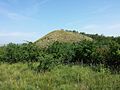
The earth pyramid of the nuclear plant as seen from the southern terrace.

The earth pyramid seen from the shield wall from the north.

View of the neck ditch in the north.

Gap and dry grass on the slope of the southern terrace.

Loess steppe on the southern slope.

The ruthenian ball thistle ( Echinops ritro subsp. Ruthenicus ) occurs only rarely in the Pannonian in Austria and is considered endangered.

The endangered Christ's-eye elephant ( Inula oculus-christi ), here withered, occurs in eastern Austria scattered or rarely.

The rare shaggy flax ( Linum hirsutum ) needs open loess soils to germinate and is considered to be endangered.

The rare and endangered Dolliner flax leaf ( Thesium dollineri ) occurs in Austria only in the Pannonian.

The Koch summer root ( Orobanche kochii ) parasitizes on the scabiosa knapweed ( Centaurea scabiosa ).

The fields in the area are home to rare Segetal species such as the three-horned bedstraw ( Galium tricornutum ), which is threatened with extinction .


Individual evidence
- ↑ a b c Wolfgang Holzner et al .: Austrian dry lawn catalog. “Steppes”, “heaths”, dry meadows, poor meadows: existence, endangerment, possibilities of their conservation. In: Green series of the Federal Ministry for Health and Environmental Protection , Volume 6, Vienna 1986, ISBN 3-900-649-065 , p. 103, object ÖK 23/4
- ^ A b c Hans P. Schad'n: The local mountains and related fortifications in Lower Austria. In: Prehistoric Research 3; Vienna 1953.
- ↑ a b c Entry about Dernberg auf NÖ-Burgen online - Institute for Reality Studies of the Middle Ages and Early Modern Times, University of Salzburg , accessed on February 18, 2018
- ↑ a b c d e Manfred A. Fischer, Karl Oswald, Wolfgang Adler: Excursions flora for Austria, Liechtenstein and South Tyrol . 3rd, improved edition. State of Upper Austria, Biology Center of the Upper Austrian State Museums, Linz 2008, ISBN 978-3-85474-187-9 .