Nappersdorf
|
Nappersdorf ( village ) locality cadastral community Nappersdorf |
||
|---|---|---|
|
|
||
| Basic data | ||
| Pole. District , state | Hollabrunn (HL), Lower Austria | |
| Judicial district | Hollabrunn | |
| Pole. local community | Nappersdorf-Kammersdorf | |
| Coordinates | 48 ° 37 '45 " N , 16 ° 11' 18" E | |
| height | 232 m above sea level A. | |
| Residents of the village | 381 (January 1, 2020) | |
| Area d. KG | 3.99 km² | |
| Statistical identification | ||
| Locality code | 03813 | |
| Cadastral parish number | 09037 | |
| Source: STAT : index of places ; BEV : GEONAM ; NÖGIS | ||
Nappersdorf is a village and a cadastral municipality in the market town of Nappersdorf-Kammersdorf in Lower Austria .
location
The village is located west of Kammersdorf on the L35 state road.
history
The place is mentioned for the first time at the beginning of the 12th century and due to the planned layout as an anger village in a south-facing form, a rather late foundation is assumed.
Building
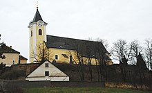
In the center of the village, around the market square, on which there is a fountain and the war memorial, there are some shops and businesses. The St. St. Stephen's parish church from the first half of the 14th century is located in the north of the village on a hill.
Lately the place has been expanded in a southerly direction, where the newly built elementary school has also been located since the 1976/77 school year. At the southeast end of the village there are numerous new single-family houses and a residential complex.
Culture and sights
- Catholic parish church Nappersdorf hl. Stephen
Individual evidence
- ↑ Nappersdorf on ndkd.at


