Dettmer's Bach
| Dettmer's Bach | ||
|
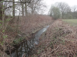
The Dettmers Bach in the lowland area near Pavenstädt |
||
| Data | ||
| Water code | DE : 313112 | |
| location | North Rhine-Westphalia , Germany | |
| River system | Ems | |
| Drain over | Ems → North Sea | |
| source | near Gütersloh - Pavenstädt 51 ° 55 ′ 0 ″ N , 8 ° 21 ′ 29 ″ E |
|
| Source height | 73 m above sea level NN | |
| muzzle | South of Gütersloh Airport Coordinates: 51 ° 55 ′ 12 ″ N , 8 ° 17 ′ 39 ″ E 51 ° 55 ′ 12 ″ N , 8 ° 17 ′ 39 ″ E |
|
| Mouth height | 64 m above sea level NN | |
| Height difference | 9 m | |
| Bottom slope | 1.7 ‰ | |
| length | 5.3 km | |
The Dettmers Bach is an orographically right tributary of the Upper Ems in North Rhine-Westphalia , Germany . It has a length of 5.3 km.
River course
The Dettmers Bach arises on the edge of the western settlement focus of Gütersloh in the area of the former farmers Pavenstädt and flows off in a westerly direction.
The water then crosses the pasture and wet meadow area east of Pavenstädt, before a nameless water from the Pavenstädter Rieselfeldern flows south of Gütersloh airport on the left. About 1.3 kilometers further west, the Dettmers Bach flows on the right into the Ems, which in this section forms the city limit towards Herzebrock-Clarholz .
Characteristic
The Dettmers Bach is a typical flat brook of the Ems sand plain with a low mean bed gradient of only 2.1 ‰ and a correspondingly low flow velocity. The brook almost exclusively crosses agricultural terrain. In some areas, the river bed was developed for meadow drainage, in these sections a more ditch-like character of the water is predominant. The Dettmers Bach was last examined for its saprobial condition in 2009 and the result was of moderate quality.
Individual evidence
- ↑ a b German basic map 1: 5000
- ↑ Topographical Information Management, Cologne District Government, Department GEObasis NRW ( Notes )
- ↑ Water assessment of the city of Gütersloh. Scroll down to "Legend"
