
Didenheim
| Didenheim | ||
|---|---|---|
.svg)
|
|
|
| local community | Brunstatt-Didenheim | |
| region | Grand Est | |
| Department | Haut-Rhin | |
| Arrondissement | Mulhouse | |
| Coordinates | 47 ° 43 ' N , 7 ° 18' E | |
| Post Code | 68350 | |
| Former INSEE code | 68070 | |
| Incorporation | January 1, 2016 | |
| status | Commune déléguée | |

Didenheim is a former French commune with the last 1,723 inhabitants (as of 2013) in the Haut-Rhin department in the Grand Est region . It was part of the arrondissement of Mulhouse , the canton of Brunstatt and a member of the municipal association Mulhouse Alsace Agglomération .
With effect from January 1, 2016, the former communities of Brunstatt and Didenheim were merged to form a commune nouvelle called Brunstatt-Didenheim .
geography
Didenheim is about six kilometers from the city center of Mülhausen and borders the city to the southwest. The Ill runs through the area. In the south and west are large forest areas, which together amount to about 50 hectares. The D 8b department road runs through the village . From Didenheim, the partly two-lane D 66 leads as a feeder to the A 36 car route five kilometers away .
history
In Didenheim, settlement remains from the Neolithic (3000–2000 BC) were found. The first written mention under the name Tudinhain comes from the year 796 in a document from the Murbach monastery . The monastery owned extensive land in Didenheim, some of which passed to the Lucelle monastery in 1301 .
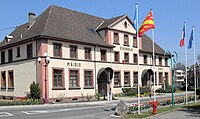
Former town hall and school building

St. Gallus Church


Population development
| year | 1962 | 1968 | 1975 | 1982 | 1990 | 1999 | 2006 |
| Residents | 1,492 | 1,897 | 1,920 | 1,902 | 1,771 | 1,758 | 1,666 |
Economy and Infrastructure
In the northwest, part of the Le Parc des Collines industrial estate belongs to Didenheim. In Didenheim there is a pre-school ( École maternelle ) and an elementary school .
literature
- Le Patrimoine des Communes du Haut-Rhin. Flohic Editions, Volume 2, Paris 1998, ISBN 2-84234-036-1 , pp. 772-774.