Dion (parish)
|
Municipality of Dion Δημοτική Ενότητα Δίου (Δίον) |
||
|---|---|---|
|
|
||
| Basic data | ||
| State : |
|
|
| Region : |
Central Macedonia
|
|
| Regional District : | Pieria | |
| Municipality : | Dion-Olympus | |
| Geographic coordinates : | 40 ° 12 ′ N , 22 ° 28 ′ E | |
| Height above d. M .: | 55 (average) m | |
| Area : | 172.743 km² | |
| Residents : | 10,066 (2011) | |
| Population density : | 58.3 inhabitants / km² | |
| Code No .: | 110203 | |
| Structure: |
2 city districts 4 local communities |
|
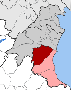
| Located in the municipality of Dion-Olymbos and in the regional district of Pieria | ||
Dion ( Greek Δίον ( n. Sg. )) Is one of three municipal districts of the municipality of Dion-Olymbos created in 2010 in the Greek region of Central Macedonia . It emerged from the community of the same name that was created in 1992 and expanded in 1997. It was named after the ancient Macedonian city of the same name .
location
The municipality of Dion is located in the north of the municipality of Dion-Olymbos and extends over 172.743 km² from the fertile coastal plain on the Thermaic Gulf west to Olympus . Adjacent municipal districts are in the north Katerini and Petra of the municipality of Katerini , in the west Olymbos of the Thessalonian municipality Elassona and in the south Litochoro .
Administrative division
The municipality of Dion emerged in 1992 from the rural municipality of Dion ( Κοινότητα Δίου Kinotita Diou ), which was founded in 1918 . With the municipal reform in 1997 , the incorporation of the rural communities of Vrondou, Karitsa, Agios Spyridon, Kondariotissa and Nea Efesos was connected. Through the merger of the municipality of Dion with the municipalities of Litochoro and Anatolikos Olymbos to form the new municipality of Dion-Olymbos after the administrative reform in 2010 , Dion was given the status of a municipality, which is divided into two municipal districts and four local communities.
| City district / local community | Greek name | code | Area (km²) | Residents 2011 | Villages and settlements |
|---|---|---|---|---|---|
| Kondariotissa | Τοπική Κοινότητα Κονταριωτίσσης | 11020301 | 26.065 | 1662 | Kondariotissa |
| Agios Spyridon | Τοπική Κοινότητα Αγίου Σπυρίδωνος | 11020302 | 13,520 | 1489 | Agios Spyridon |
| Vrondou | Δημοτική Κοινότητα Βροντούς | 11020303 | 67.183 | 1902 | Vrondou |
| Dion | Τοπική Κοινότητα Δίου | 11020304 | 31,375 | 1424 | Dion, Platanakia |
| Karitsa | Δημοτική Κοινότητα Καρίτσης | 11020305 | 19.275 | 2025 | Karitsa |
| Nea Efesus | Τοπική Κοινότητα Νέας Εφέσου | 11020306 | 15.325 | 1564 | Nea Efesus |
| total | 110203 | 172.743 | 10066 | ||
Individual evidence
- ↑ National Statistical Service of Greece (ΕΣΥΕ) according to 2001 census , p. 116 (PDF, 793 kB)
- ↑ Results of the 2011 census at the National Statistical Service of Greece (ΕΛ.ΣΤΑΤ) ( Memento from June 27, 2015 in the Internet Archive ) (Excel document, 2.6 MB)
- ↑ Κεντρική Ένωση Δήμων και Κοινοτήτων Ελλάδας (ΚΕΔΚΕ) Ελληνική Εταιρία Τοπικής Ανάπτυξης και Αυτοδιοίκησης (Ε.Ε.Τ.Α.Α.) (ed.): Λεξικό Διοικητικών Μεταβολών των Δήμων και Κοινοτήτων (1912-2001). Volume 1 (Τόμος Α, α – κ), Athens 2002, ISBN 960-7509-47-1 , p. 92 .; Κεντρική Ένωση Δήμων και Κοινοτήτων Ελλάδας (ΚΕΔΚΕ) Ελληνική Εταιρία Τοπικής Ανάπτυξης και Αυτοδιοίκησης (Ε.Ε.Τ.Α.Α.) (ed.): Λεξικό Διοικητικών Μεταβολών των Δήμων και Κοινοτήτων (1912-2001). Volume 2 (Τόμος Β, λ – ω), Athens 2002, ISBN 960-7509-47-1 , p. 70.

