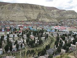
La Oroya district
| La Oroya district | |
|---|---|
 The district of La Oroya is located in the east of the province of Yauli (marked in red) |
|
| Basic data | |
| Country | Peru |
| region | Junín |
| province | Yauli |
| Seat | La Oroya |
| surface | 380 km² |
| Residents | 14,021 (2017) |
| density | 37 inhabitants per km² |
| founding | November 15, 1893 |
| ISO 3166-2 | PE-JUN |
| Website | laoroya.gob.pe (Spanish) |
| politics | |
| Alcalde Provincial | Saturnino Gerson Camargo Zavala (2019-2022) |
| Political party | Movimiento Político Regional Perú Libre |
| Asentamiento Marcavalle | |
Coordinates: 11 ° 31 ′ S , 75 ° 55 ′ W
The district of La Oroya (Spanish: Distrito de La Oroya ) is one of the ten districts that make up the province of Yauli in the administrative region of Junín in central Peru . The La Oroya District was founded on November 15, 1893. District and provincial administrations are located in the mining and industrial town of the same name, La Oroya, which is 3745 m high and has 11,425 inhabitants (as of 2017).
Geographical location
The district of La Oroya extends over an area of 380 km² in the east of the province of Yauli. The Rio Mantaro river flows through the district in a south-southeast direction. Its tributary Río Yauli runs along the northwestern district boundary.
population
The population has decreased in the last few decades. In 1993 the population was 29,783. In 2007 there were 18,606, in 2017 14,021.
Cities and towns in the district
The district of La Oroya consists of the following localities:
- Campagno
- Chagacancha
- Curipata
- Huancamarca
- Huari
- Huaynacancha
- La Oroya
- Quiulla
- Sajarumi
- Tincocancha
Individual evidence
- ^ Junín Region, Provinces and Districts . www.citypopulation.de. Retrieved November 8, 2019.
