Marcapomacocha District
| Marcapomacocha District | |
|---|---|
 The Marcapomacocha District is located in the northwest of the Yauli Province (marked in red) |
|
| Basic data | |
| Country | Peru |
| region | Junín |
| province | Yauli |
| Seat | Marcapomacocha |
| surface | 888.6 km² |
| Residents | 835 (2017) |
| density | 0.9 inhabitants per km² |
| founding | January 2, 1857 |
| ISO 3166-2 | PE-JUN |
| Website | munimarcapomacocha.gob.pe (Spanish) |
| politics | |
| Alcalde District | Harry Helbert Moya Astudillo (2019-2022) |
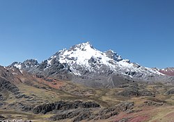
| Nevado Rajuntay (5412 m) | |
Coordinates: 11 ° 24 ′ S , 76 ° 20 ′ W

The Marcapomacocha district is located in the Yauli province of the Junín region in central Peru . The district was founded on January 2, 1857. It has an area of 888.56 km². At the 2017 census, 835 people lived in the district. In 1993 the population was 1253, in 2007 it was 1267. The district administration is located in the village of Marcapomacocha ( ⊙ ) at 4415 m ( ) with 210 inhabitants (as of 2017). Marcapomacocha is located 50 km west of the provincial capital La Oroya .
Geographical location
The Marcapomacocha district is located in the northwest of the Yauli province in the Andean highlands on the eastern flank of the Western Peruvian Cordillera . The upper reaches of the Río Mantaro runs south along the north-eastern district boundary . Its tributary Río Pucayacu flows north along the southeastern border of the district. Much of the district is drained via the Río Corpacancha to the east to the Río Mantaro. There are several lakes in the Marcapomacocha district, including the Laguna Marcapomacocha . In the south of the district rises the 5412 m high Nevado Rajuntay (or Raujunte).
The Marcapomacocha district borders in the north with the district Santa Bárbara de Carhuacayán , in the northeast with the district Junín ( province Junín ), in the southeast with the district Morococha , in the south with the districts Chicla , Laraos and Huanza ( province Huarochirí ), in the west the districts of Huaros ( province of Canta ) and Atavillos Alto ( province of Huaral )
Localities
There are five Anexos in the district:
- Corpacancha ( ⊙ 14 km east-northeast of Marcapomacocha)
- Cuyo ( ⊙ 6.5 km northwest of Marcapomacocha)
- Sángrar ( ⊙ 7.5 km east-southeast of Marcapomacocha)
- Santa Ana ( ⊙ 17 km east-southeast of Marcapomacocha)
- Yántac ( ⊙ 10 km northwest of Marcapomacocha)
![]() Map with all coordinates: OSM | WikiMap
Map with all coordinates: OSM | WikiMap
Individual evidence
- ^ A b Peru: Junín - Provinces & Districts . www.citypopulation.de. Retrieved March 27, 2020.
