
Don Juan Lake
| Don Juan Lake | ||
|---|---|---|

|
||
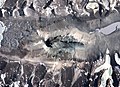
| Map of the Wright Valley with the lake | ||
| Geographical location | Wright Valley , Victoria Land , East Antarctica | |
| Drain | none | |
| Location close to the shore |
Vanda station (14 km east) |
|
| Data | ||
| Coordinates | 77 ° 34 ′ 0 ″ S , 161 ° 11 ′ 0 ″ E | |
|
||
| Altitude above sea level | 151 m | |
| surface | 0.03 km² | |
| length | 300 m | |
| width | 100 m | |
| volume | 3000 m³ | |
| Maximum depth | 0.1 m | |
| Middle deep | 0.1 m | |
|
particularities |
Salinity over 40% |
|

The Don Juan Pond , also Don Juan Pond , is a small and very shallow hypersaline lake in the west end of Wright Valley (South Fork), Victoria Land , Antarctica , 9 km west of Vandasees . It is wedged between the Asgard Range ( Oliver Peak ) in the south and the Dais in the north. At the western end there is a small tributary and a rock glacier . With a salinity of over 40%, the Don Juan Lake is one of the salty waters on earth.
discovery
The lake was discovered in 1961 and after two helicopter pilots, Lt. Don (ald) Roe and Lt. John Hickey, named who flew the helicopter for the first survey of the waters. During this first investigation, temperatures of −30 ° C prevailed and the very salty water was still in a liquid state.
Salinity
Don Juan Lake is a shallow hypersaline lake with a flat bottom. It has a higher salinity than the Dead Sea and Lake Assal in Djibouti . Only the Gaet'ale in Ethiopia has an even higher salt content.
The lake is described as a groundwater outlet zone. The dominant ions in the solution are calcium and chloride ions. The area around Lake Don Juan is covered in sodium chloride (NaCl) and calcium chloride (CaCl 2 ) salts that were left behind when the water evaporated. The area and volume of Lake Don Juan fluctuates over time. According to the " USGS topo map" from 1977, its area was around 0.25 km². Apparently, however, the size of the lake has shrunk significantly in recent years. The maximum depth in 1993/94 was described as "one foot deep" (approx. 30 cm). In January 1997 it was about 10 cm and in December 1998 the lake was almost dry except for an area of a few dozen square meters. Most of the water that was left was confined to depressions around larger boulders in the lake.
The calculated composition for the water is CaCl 2 3.72 mol / kg and NaCl 0.50 mol / kg. This solution only freezes at a temperature of -51.8 ° C. This corresponds to 413 g CaCl 2 and 29 g NaCl per kg of water (approx. 44.2%).
The Don Juan Lake is the type locality of the rare mineral Antarcticit , a water-containing calcium chloride.

View down into the valley with the lake
Aerial photo A

Aerial photo B
.jpg)


literature
- Yamagata, N., T. Torii, S. Murata: Report of the Japanese summer parties in Dry Valleys, Victoria Land, 1963-65 ; V - Chemical composition of lake waters. Antarctic Record 29: 53-75.
Web links
- Great Zoom into Don Juan Pond, Antarctica
- BZ SIEGEL, G. MCMURTY u. a .: Life in the calcium chloride environment of Don Juan Pond, Antarctica. In: Nature. 280, 1979, pp. 828-829, doi : 10.1038 / 280828a0 .
- McMurdo Dry Valleys MCM Lakes Data
- Don Juan Lake in the Geographic Names Information System of the United States Geological Survey
- Antarctica: nitrous oxide discovery on salt lake amazes researchers. In: Spiegel Online . April 26, 2010, accessed January 5, 2015 .
Individual evidence
- ^ A b G. M. Marion, "A theoretical evaluation of mineral stability in Don Juan Pond, Wright Valley, Victoria Land", Antarctic Science (1997), 9: 92-99, Cambridge University Press doi : 10.1017 / S0954102097000114 .
- ↑ http://www.mcmlter.org/data/lakes/locations/lakedsc.dat
- ↑ Tetsuya Torii, Joyo Ossaka: Antarcticite: A New Mineral, Calcium Chloride Hexahydrate, Discovered in Antarctica . In: Science. 1965, 149, pp. 975-977.