Asgard Range
| Asgard Range | ||
|---|---|---|
|
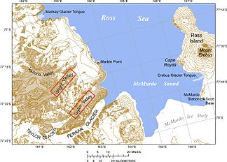
Map of McMurdo Sound with the Asgard Range between the Taylor Valley and the Wright Valley |
||
| Highest peak | Round Mountain ( 2410 m ) | |
| location | Antarctic dry valleys , Victoria Land | |
| part of | Transantarctic Mountains | |
|
|
||
| Coordinates | 77 ° 37 ′ S , 162 ° 17 ′ E | |
|
Topographic map of the Antarctic dry valleys |
||
The Asgard Range ( German Asgard Mountains ) is a mountain range between the Wright Valley and the Taylor Valley ( Antarctic Dry Valleys ) in East Antarctic Victoria Land . It extends from the top of Taylor Glacier in the west, to Marble Point in the east, where it borders McMurdo Sound . The mountain range is about 80 km long and about 10 km wide and has its highest point on Round Mountain at 2,410 m. Its mean heights are around 1,700 to 1,900 m. It is part of the Transantarctic Mountains .
The Asgard Range was named by the Victoria University of Wellington Antarctic Expedition (VUWAE) (1958–59) after Asgard , the seat of the Nordic gods.
Formations and mountain groups
- Bifrost Ledge
- Campbell Terrace
- Colosseum Cliff
- East Groin
- Flint Ridge
- Gallagher Ridge
- Horowitz Ridge
- Hothem cliffs
- Linnaeus Terrace ( Antarctic Specially Protected Area No. 138)
- MacDonald Hills
- Medley Ridge
- Morelli Ridge
- Nichols Ridge
- Noxon cliff
- Plane table
- Roa Ridge
- Tractor Corner
- Vortex Col
- West Groin
mountains
- Ball Peak (1700 m)
- Mount Baldr (2200 m)
- Bromley Peak (2020 m)
- Brunhilde Peak
- Mount Carnes
- Mount Coleman (1110 m)
- Mount Darby (1750 m)
- Dominion Hill (900 m)
- Mount Fleming (2200 m)
- Flint Hill (955 m)
- Mount Freya (2225 m)
- Mount Grendal (2000 m)
- Hess Mesa
- Hetha Peak (1700 m)
- Mount Hall (1800 m)
- Harp Hill (750 m)
- Harris Peak (1750 m)
- Hind Turret
- Hoehn Peak (2000 m)
- Hoffman Peak (1550 m)
- Mount Holm-Hansen (1920 m)
- Idun Peak
- Inland forts
- Mount Irvine (2067 m)
- Mount JJ Thomson
- Mount Jord (1400 m)
- Lyons Cone (1850 m)
- Kaminuma Crag (1750 m)
- Mount Knox (800 m)
- Mount Keohane (1250)
- Kottmeier Mesa (2120 m)
- Mount Loke
- Matterhorn (1600 m)
- Mattox bastion
- Mount McLennan (> 1600 m)
- Mount Newall (1920 m)
- Northwest Mountain (2286 m)
- Obelisk Mountain (2200 m)
- Mount Odin (2100 m)
- Oliver Peak (2410 m)
- Perk Summit (1750 m)
- Ponder Peak (1412)
- Round Mountain (2410 m)
- Mount Saga (1750 m)
- Sagittate Hill (850 m)
- Saint Pauls Mountain
- Siegmund Peak
- Siegfried Peak
- Mount Thor (2000 m)
- Mount Thundergut
- Twickler Cone (1950 m)
- Mount Ulla (1920 m)
- Utgard Peak (2050 m)
- Mount Valhalla
- Mount Valkyrie
- Veli Peak
- Vogler Peak (2050 m)
- Wolak Peak
Mountain basins and valleys
- Colony Cirque
- David Valley
- Donner Valley
- Fenrir Valley
- Flory Cirque
- Hallet Valley
- Jotunheim Valley
- King Valley
- Koenig Valley
- Martin Cirque
- Mudrey Cirque
- Nibelungen Valley
- Njord Valley
- Odin Valley
- Pearse Valley
- Sessrumnir Valley
- Territory Cirque
- Tiw Valley
- Tyrol Valley
glacier
Numerous glaciers flow from the Asgard Range into the neighboring dry valleys:
- Taylor Valley
- Wright Valley
Lakes
literature
- ↑ Ordinance on specially protected areas, specially managed areas, historical sites and monuments in the Antarctic (Antarctic Protected Areas Ordinance - AntSchV) of April 25, 2005 ( PDF ; 141 kB), accessed on November 16, 2019.
- ↑ Management Plan for Antarctic Specially Protected Area (ASPA) No.138 Linnaeus Terrace, Asgard Range, Victoria Land . ATCM XXXVI Final Report, Measure 8 (2013) Annex ( PDF ; 6.3 MB)


