Donatsfriedhof
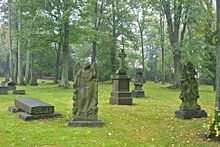
The Donatsfriedhof is a cemetery in Freiberg in Saxony . It was laid out at the beginning of the 16th century outside the city wall as a plague cemetery . Since 1987 it has only been used sporadically.
location
The cemetery is outside the former Freiberg city wall near the Donatsturm, which marks the eastern entrance to medieval Freiberg. The Jakobikirche stands on its edge . It is limited to the northwest and north by Donatsring and Himmelfahrtsgasse, which leads to the extensive mining facilities of the Himmelfahrt Fundgrube , to the east by the street Am Ostbahnhof, where the main entrance is located, to the south by Dresdner Straße and to the west by Hornstraße where there is another entrance. It covers an area of 63.8 hectares.
history

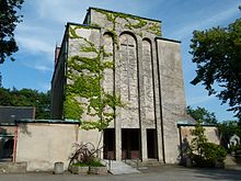
The cemetery has been in use since 1506 or 1521 according to the plans of the city doctor and later mayor of Freiberg Ulrich Rülein von Calw , but is probably much older. It belonged to the wooden Donatskirche, first mentioned in 1225. This was named after St. Donatus of Arezzo , the patron saint of the Meissen diocese and namesake of the Meissen Cathedral . The churchyard was first mentioned in 1430, but the church was demolished in 1443 and replaced by a chapel. In 1531, Duke Heinrich the Pious declared the cemetery to be the central burial place of Freiberg. Between 1567 and 1588 it received a permanent walling, and in 1834/1835 an extension to the east, which was then mainly used. In 1839 the large gatehouse built according to plans by Eduard Heuchler was inaugurated in the west. In the 1920s the cemetery was given a crematorium , which was decommissioned in 2002. After a decision by the city council to partially close the cemetery in 1987, burials only take place in grave sites that have already been sold. In 2014 it was decided to reactivate the cemetery.
Cemetery complex
The cemetery comprises around 2,600 grave sites, including around 150 historical tombs , mostly made of sandstone . Only four of the numerous family tombs have survived, such as the Gerlach family's tomb house built around 1700. The oldest tombstone dates from 1676 and shows an angel with an inscribed cloth.
The facility including the crematorium is a listed building . As an object within the “Historic Old Town Freiberg”, the historical part is a selected site for the candidacy for the UNESCO World Heritage “ Ore Mountains Mining Region ”.
Graves of famous people
Well-known personalities buried in the cemetery are:
- Friedrich Wilhelm Heinrich von Trebra (1819)
- Wilhelm August Lampadius (1842)
- Johann Carl Free Life (1846)
- August Ferdinand Anacker (1854)
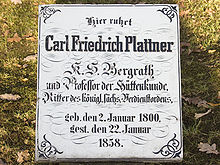
- Carl Friedrich Plattner (1858)
- Christian Friedrich Brendel (1861)
- Julius Weisbach (1871)
- August Breithaupt (1873)
- Bernhard von Cotta (1879)
- Friedrich Wilhelm Schwamkrug (1880)
- Theodor Richter (1898)
- Carl Hermann Müller (1907)
- Esther von Kirchbach (1946)
- Karl Kegel (1959)
- Georg Spackeler (1960)
- Werner Gimm (1977)
literature
- Helmuth Albrecht et al .: Implementation study of the Freiberg mining area . Establishment and definition of the world heritage areas and buffer zones as part of the Ore Mountains Mining Region project. Ed .: Förderverein Montanregion Erzgebirge eV SAXONIA site development and management company, Freiberg 2012, 4.1 Donatsfriedhof (historical part), p. 34 .
Web links
Individual evidence
- ↑ a b Herbert Pforr: Start of the mining science age with "A useful mountain booklet" by the Freiberg renaissance scholar Doctor Ulrich Rülein von Calw (1465-1523), Freiberg, Saxony . In: Reports of the Federal Geological Institute . tape 35 , 1996, pp. 282 ( Online [PDF; 934 kB ]).
- ↑ Werner Lauterbach : Agricola and the friendship with Mosellanus . In: Friedrich Naumann (Ed.): Georgius Agricola, 500 years . Birkhäuser, Basel, Boston, Berlin 1994, pp. 248 .
- ↑ Donatsfriedhof: The cemetery wall is being renovated further. In: Official Journal of the University City of Freiberg. No. 10, May 26, 2010, p. 3 ( PDF )
- ^ Hubert Ermisch : Walks through the city of Freiberg in the Middle Ages . In: New archive for Saxon history and antiquity . tape 12 , 1891, p. 150 ( digitized version ).
- ↑ Cemetery Ordinance of the City Freiberg from 13.01.2006 ( Memento of 9 October 2016 Internet Archive )
- ↑ Freiberg's oldest cemetery is to be reopened. In: Free Press July 23, 2014.
- ↑ Montanregion Krušné hory - Erzgebirge, ops (ed.): Monuments of mining in the Montanregion Erzgebirge / Krušnohoří . 2014, Hornická krajina Brand-Erbisdorf / Montanlandschaft Brand-Erbisdorf, p. 76–78 (German, Czech, montanregion.cz [PDF; 5.9 MB ]). PDF, 5.9 MB ( Memento of the original from March 6, 2016 in the Internet Archive ) Info: The archive link was inserted automatically and has not yet been checked. Please check the original and archive link according to the instructions and then remove this notice.
Coordinates: 50 ° 55 ′ 3.8 ″ N , 13 ° 21 ′ 14.7 ″ E


