
Dossenheimer Klause

The Dossenheimer Klause is a cave-like collection of one large and several small rocks in the Odenwald north-east of Dossenheim in the Rhein-Neckar district in northwestern Baden-Württemberg .
Location and nature

The Klause lies over a kilometer east-northeast of the village center of Dossenheim on the southeast slope of the rear Kirchberg in the upper Dossenheimer Mühltal down to over 280 m above sea level. NHN . Roughly across from the Dossenheimer Mühlbach , which runs in the valley, lies the Kronenburg ruin on the spur of the mouth of the left upper course of the stream. On the mountain side past the hermitage, a gravel forest path leads diagonally up the slope to the Kirchberg ridge, shortly before it branches off to the right of an initially still little sloping clay path towards the upper Mühltal, which, where it passes the rocks at the acute angle of the paths, branches off to the right. widens to a fairly level small forecourt before continuing as a beaten path.
The largest rock , consisting of rhyolite , lies on the slope, it is supported by several smaller ones, so that a cavity with an area of around 10 square meters and up to 2.70 meters in height remains free. A small entrance about half a meter high leads inside. The walls in the cave are lined with stones, the ceiling is the big rock, the floor is covered with earth. A 10 to 20 centimeter wide shaft leads diagonally upwards from the cave and emerges from the side of the rock at about outer ground level.
The Hermit von Dossenheim
In the second half of the 18th century, a hermit named Johann Georg Kernstock lived in this cave , who came to Bergstrasse from Lower Austria in 1765 . He belonged to the Third Order of the Franciscans . An entry in the Catholic church book of August 8, 1765 also reports that he had converted to the Catholic faith as a Lutheran . After he came to Dossenheim, he chose the hermitage as his place of residence, for which he then further hollowed out the rock and provided the walls with stone walls. He also created the small shaft that he presumably used as a hood .
The hermit was welcomed by the population of Dossenheim and the pastor, and because he helped with the Catholic Church, he collected donations, among other things. As a hermit, he probably lived in the hermitage only temporarily, but during this time, due to his special way of life , he drew some visitors from far away to the hermitage. Kernstock is also said to have been known as a miracle healer.
Todays situation
The hermitage was left to its own devices for a long time and so fell into disrepair over time. The eastern wall partially collapsed, creating a small hole. Heavy rains added to it, washing dirt and mud into the cave.
Two members of the association, which takes care of the preservation of the Schauenburg ruins, took care of the hermitage from the summer of 2011. They removed the washed-in soil, filled the hole in the wall and repaired other damaged parts. This means that the Dossenheimer Klause is largely in the same condition as it was 200 years ago.

A side wall of the small cave
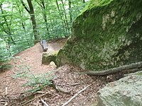
Look past the hermitage, to the south, on the right the big rock
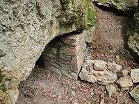
The entrance, with the wall repaired


literature
- Rudolf Conzelmann: Dossenheim. The story of a 1200 year old mountain road community. Municipal administration, Dossenheim 1966, OCLC 311569268 .
- Jens Seeling: Heidelberg - Walks through the history of the earth , JSV Jens Seeling Verlag, 2005, ISBN 9783938973004 .
Individual evidence
- ↑ Heights of up to 304 m are sometimes mentioned. (see also web links)
- ↑ Seeling 2005, p. 120 f.
- ↑ a b c d Hermit also worked as a faith healer. in: Mannheimer Morgen from April 14, 2012.
- ↑ as of summer 2014; own observations
- ↑ a b c Conzelmann 1966, pp. 216/217.
- ↑ A very pious Christian life. in: Mannheimer Morgen from October 4, 2014.
- ↑ Sign on the hermitage
- ↑ Schauenburg Blog - The Dossenheimer Klause onsehenburg.blogspot.de
Web links
- Location of the Dossenheimer Klause in the Dossenheimer Mühltal on the geodata viewer
- Klause Dossenheim on wandern-im-odenwald.kruemelhuepfer.de (picture still during renovation)
Coordinates: 49 ° 27 ′ 15 " N , 8 ° 41 ′ 34.8" E