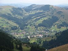
Dowhopillja
| Dowhopillja | ||
| Довгопілля | ||

|
|
|
| Basic data | ||
|---|---|---|
| Oblast : | Chernivtsi Oblast | |
| Rajon : | Putyla district | |
| Height : | 531 m | |
| Area : | Information is missing | |
| Residents : | 1,227 (2004) | |
| Postcodes : | 59120 | |
| Area code : | +380 3738 | |
| Geographic location : | 48 ° 4 ' N , 24 ° 58' E | |
| KOATUU : | 7323581001 | |
| Administrative structure : | 4 villages | |
| Address: | 59120 с. Довгопілля | |
| Statistical information | ||
|
|
||
Dowhopillja ( Ukrainian Довгопілля ; Russian Долгополье Dowgopolje , Romanian Câmpulung pe Ceremuş , German until 1918 Russian Dolhopole , Polish Dołhopol ) is a village in the Eastern Carpathians in the west of the Ukrainian Chernivtsi Oblast with about 1200 inhabitants (2004).
The village is located at an altitude of 531 m in the valley of the Bilyj Tscheremosch ("White Cheremosh") in the historical landscape of Bukovina on the border with Galicia . The village is located about 13 km northwest of the Putyla district center and about 110 km southwest of the Chernivtsi oblast center . The village of Dowhopole in Ivano-Frankivsk Oblast is located on the opposite bank of the Bilyj Cheremosh .
Dowhopillja is the administrative center of the district council of the same name in Putyla district , to which the villages of Hreblyna ( Греблина ), Plyta ( Плита ) and Stebni ( Стебні ) belong.
Web links
- Dołhopol . In: Filip Sulimierski, Władysław Walewski (eds.): Słownik geograficzny Królestwa Polskiego i innych krajów słowiańskich . tape 2 : Derenek – Gżack . Sulimierskiego and Walewskiego, Warsaw 1881, p. 107 (Polish, edu.pl ).
Individual evidence
- ↑ Dowhopillja on the official website of the Verkhovna Rada; accessed on February 6, 2017


