DuPage River
| DuPage River | ||
|
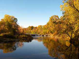
Warrenville Grove Forest Conservation Area on the West Branch of the DuPage River |
||
| Data | ||
| Water code | US : 407441 | |
| location | Will County , Illinois , USA | |
| River system | Mississippi River | |
| Drain over | Des Plaines River → Illinois River → Mississippi → Gulf of Mexico | |
| Confluence of |
East Branch and West Branch DuPage River 41 ° 42 ′ 7 ″ N , 88 ° 8 ′ 51 ″ W |
|
| muzzle | in the Des Plaines River coordinates: 41 ° 24 ′ 56 " N , 88 ° 13 ′ 10" W 41 ° 24 ′ 56 " N , 88 ° 13 ′ 10" W
|
|
| length | 45.5 km | |
| Discharge at the Shorewood A Eo gauge : 839 km² |
MQ 1941/2016 Mq 1941/2016 |
9.5 m³ / s 11.3 l / (s km²) |
The DuPage River is a 45.5 km long tributary of the Des Plaines River in the US state of Illinois .
course
Two streams flow towards the river. The west branch of the DuPage River is 35 miles long and has its source in Schaumburg in Campanelli Park in Cook County and flows further south through all of DuPage County including the towns of Bartlett , Wheaton , Warrenville , Winfield and Naperville .
The East Branch of the DuPage River is 40.2 km long and has its source in Bloomingdale and flows south through Glendale Heights , Glen Ellyn , Lisle , Woodridge , through parts of Naperville and parts of Bolingbrook . The two arms meet in a place between Naperville and Bolingbrook. The combined DuPage River flows from this point further south through Plainfield and then west of Joliet before finally flowing into the Des Plaines River.
Floods
Like many local bodies of water, the two branches of the DuPage River overflowed in the 1996 flood after approximately 430 mm of rain fell in the area over a 24-hour period on July 18-19, 1996. Further flooding in the Washington Street area in Naperville and Illinois Route 53 in Glen Ellyn was frequent because the streets are near their respective arms of the river. The city of Naperville has demolished many of the homes and businesses affected. DuPage County has also demolished houses in the Illinois Route area with financial support from the United States Department of Transportation .
Individual evidence
- ↑ a b c d U.S. Geological Survey. National Hydrography Dataset high-resolution flowline data. The National Map , accessed May 13, 2011
- ↑ USGS 05540500 DU PAGE RIVER AT SHOREWOOD, IL
- ↑ Dupage River Flooding ( Memento of the original from September 11, 2017 in the Internet Archive ) Info: The archive link was inserted automatically and has not yet been checked. Please check the original and archive link according to the instructions and then remove this notice.
Web links
