Des Plaines River
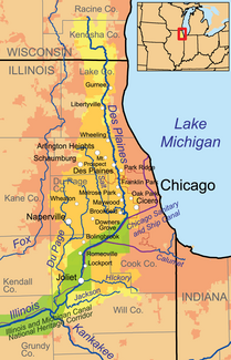
The Des Plaines River is the right headwaters of the Illinois River in the US states of Illinois and Wisconsin . It has a length of 214 km. The catchment area (excluding the DuPage River ) covers an area of 4025 km² (3418 km² in Illinois, 607 km² in Wisconsin). The mean discharge in Joliet is 108 m³ / s. This level is located below the confluence of the Chicago Sanitary and Ship Canal .
course
The Des Plaines River rises 2 km east-southeast of Union Grove in Racine County in southeast Wisconsin. The river initially flows south, then a little east. It then turns south and runs for 80 km parallel to the west bank of Lake Michigan, about 10 km away . After a total of 46 kilometers of river he crosses the border to Illinois. It later passes Gurnee , Libertyville and Des Plaines and several western suburbs of Chicago . Then he turns to the southwest. The Chicago Sanitary and Ship Canal now runs roughly 40 km parallel to the Des Plaines River before it flows into it at Joliet. Another 25 km downstream, the Des Plaines River finally meets the Kankakee River , with which it forms the Illinois River. The most important natural tributary is the DuPage River, which flows into the Des Plaines River from the right just a few kilometers above the Kankakee River.
Web links
Individual evidence
- ↑ a b Des Plaines River in the Geographic Names Information System of the United States Geological Survey
- ↑ a b Des Plaines Watershed Discovery - About the Des Plaines . www.illinoisfloodmaps.org. Retrieved July 7, 2017.
- ↑ USGS 05529000 DES PLAINES RIVER NEAR DES PLAINES, IL
- ↑ USGS 05533600 DES PLAINES RIVER NEAR LEMONT, IL
- ↑ USGS 05537980 DES PLAINES RIVER AT ROUTE 53 AT JOLIET, IL


