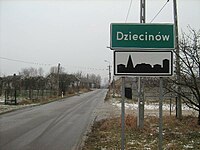
Dziecinów (Powiat Otwocki)
| Dziecinów | ||
|---|---|---|

|
|
|
| Basic data | ||
| State : | Poland | |
| Voivodeship : | Mazovia | |
| Powiat : | Otwock | |
| Gmina : | Sobienie-Jeziory | |
| Geographic location : | 51 ° 59 ′ N , 21 ° 19 ′ E | |
| Height : | 95 m npm | |
| Residents : | 704 (2007) | |
| Postal code : | 08-446 | |
| Telephone code : | (+48) 25 | |
| License plate : | WOT | |
| Economy and Transport | ||
| Street : | Droga wojewódzka 799 | |
| Droga wojewódzka 801 Warsaw - Puławy | ||
| Next international airport : | Warsaw | |
Dziecinów is a village in the municipality of Sobienie-Jeziory in the Powiat Otwocki in the Masovian Voivodeship , Poland .
The village is located 5 km north of the main town of the municipality and 15 km south of the district town of Otwock on the Vistula .
From 1975 to 1998 the village belonged to the Siedlce Voivodeship .
The railway line from Skierniewice to Łuków runs north of Dziecinów . Droga wojewódzkas 799, 801 and 805 meet in the village.
Web links
Commons : Dziecinów - collection of images

