Eigerøya
| Eigerøya | ||
|---|---|---|
| Waters | Skagerrak | |
| Geographical location | 58 ° 27 ′ 0 ″ N , 5 ° 57 ′ 0 ″ E | |
|
|
||
| length | 6 km | |
| width | 6 km | |
| surface | 19.9 km² | |
| Highest elevation | 131 moh. | |
| Residents | 2322 117 inhabitants / km² |
|
Eigerøya is an island west from the town Egersund in the municipality of Eigersund in the Fylke Rogaland on the southwest coast of Norway .
geography
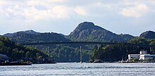
The island is 19.9 km² and has 2473 inhabitants (2017). It is separated from the mainland in the east and north by an approximately 13 km long, mostly only 200-300 m wide sound (the "Sundet" or "Søra Sundet" and "Nordra Sundet") and in the north by the here only about Eigerøy bru, which crosses 50 m wide “Nysund”, is 23.75 m high and inaugurated in 1951, is connected to it by traffic.
Eigerøya is about 6 km long in north-south direction and is divided from the south by the 4 km long fjord "Lunnarviga" into two parts, which are only connected in the north by an isthmus at its narrowest point about 400 m wide. The smaller western part ("Nordre Eigerøya") is relatively flat, the eastern part ("Søre Eigerøya") is rocky and rises to 131 m.
Economy and Transport
On the east side of the island, across from Egersund, there are several large fish processing plants as well as an Aker Solutions plant that makes parts for drilling rigs .
A lighthouse , Vibberodden fyr , on an archipelago immediately south of the island secures the southern entrance to Egersund. A second lighthouse, Eigerøy fyr, on the small island Midbrødøya immediately to the west and only separated from Eigerøya by a 20 m wide sound, but connected by a bridge, ensures shipping traffic along the coast .
Web links
- Store Norske Leksikon: Eigerøya (Norwegian)


