Eilean Kearstay
| Eilean Kearstay | ||
|---|---|---|
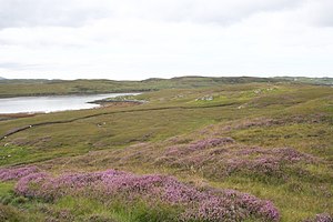
| View from Lewis on Eilean Kearstay | ||
| Waters | North Atlantic | |
| Archipelago | Outer Hebrides | |
| Geographical location | 58 ° 12 ′ 1 ″ N , 6 ° 46 ′ 13 ″ W | |
|
|
||
| length | 1.5 km | |
| width | 690 m | |
| surface | 77 ha | |
| Highest elevation | 37 m ASL | |
| Residents | uninhabited | |
Eilean Kearstay , Scottish Gaelic Eilean Chearstaidh , is a Scottish island in the Outer Hebrides . It is located in the council area of the same name and was historically part of the traditional county of Ross-shire or the administrative county of Ross and Cromarty .
geography
Eilean Kearstay is located in Loch Roag Bay off the west coast of the Isle of Lewis . Located near the head of the bay at the entrance to Loch Kinhoulavig , the side bay , Eilean Kearstay is only separated from the Lewis coast by 150 meters and 350 meters wide waterways to the east and southwest, respectively. The distances to the surrounding islands of Great Bernera in the west and Keava in the north are at least 250 meters and 500 meters, respectively. Callanish is one mile away on Lewis .
The island has a maximum length of 1.5 kilometers and a width of 690 meters. This results in an area of 77 hectares . Its highest point rises 37 meters above sea level.
history
There is a cairn at the highest point on the island . In 1990 Great Bernera's Laird sold the island to two Australians. Just three years later it was sold again.
Individual evidence
- ^ A b c Information in the Gazetteer for Scotland
- ↑ a b Measurement of Google Maps
- ^ Rick Linvingstone's Table of the Islands of Scotland

