Single bed
|
Single bed
City of Starnberg
Coordinates: 48 ° 1 ′ 30 ″ N , 11 ° 22 ′ 18 ″ E
|
|
|---|---|
|
In the picture at the bottom right Leutstetten with the Enbettl adjoining it in a south-easterly direction.
|
Einbettl is a village within the Upper Bavarian district town of Starnberg . The Bavarian State Office for Statistics runs Einbettl as an independent district of Starnberg. In terms of community policy , the settlement is part of the Starnberg district of Leutstetten , to whose administrative area it belonged until it was incorporated on May 1, 1978.
location
The village of Einbettl is located on the northern edge of the Leutstettener Moos on the local road connecting Leutstetten and Wangen . The development of Einbettl begins immediately at the southern exit of the village of Leutstetten, so that the two villages have grown together structurally.
history
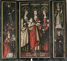
Einbettl of 1607 is the occasion of a report provost of monastery Schlehdorf a few hundred meters south Leutstettens standing wooden chapel was first mentioned in writing. Another report says that it was a place of pilgrimage where three Bethen were revered as helpers in the desire for children and childbirth as well as protectors against the plague. In 1719 the dilapidated place of worship was rebuilt as a stone construction. After a significant decline in visitor numbers, interest in maintaining the chapel waned at the beginning of the 19th century. Parts of their furnishings were brought to the chapel of Leutstetten Castle , a panel with the Bethen Ainpet (from which the place name is derived), Gberpet and Firpet , a foundation of Regina von Starzhausen, in Leutstetten's Church of St. Alto. A buyer bought land and walls for 400 guilders and built his Einbettlgütl here , also known as Schusterhäusl elsewhere .
In 1928 Einbettl is mentioned as a district of Leutstetten and is described as follows: Solitude, 6.5 km to the Catholic parish Gauting (belonging), school and post office to Leutstetten (belonging) 0.5 km, 2 residents, 1 residential building. A former teacher from Leutstetten referred to the Einbettlgütl as a single homestead in 1953. The strong growth of the place through new buildings and influx is therefore likely to have taken place only from the 1960s. The development was favored by the location of Leutstetten at the foot of a terminal moraine wall , which encloses the place in a horseshoe shape and only makes village expansion possible to a limited extent. New buildings were therefore mainly built in the immediately south-west facing corridor Einbettl.
Attractions
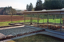
Leutstetten's Villa rustica can be reached via a farm road from Einbettl . It is a Roman manor from the second century AD, which has been archaeologically examined and partially uncovered.
literature
- Gertrud Rank, Michael Schmid: A piece of heaven. Art historical insights into the Starnberg church landscape. Kulturverlag Starnberg, Starnberg 2008, ISBN 978-3-941167-03-2
Web links
- Bavarian State Library Online
- Astrid Becker: The Holy Sisters of Sankt Alto , article in the Starnberg local edition of the Süddeutsche Zeitung, online version of December 21, 2017, accessed on March 7, 2018
Individual evidence
- ↑ BayernPortal, official municipal parts , accessed on March 7, 2018
- ↑ G. Rank and M. Schmid, pp. 72-75
- ↑ List of localities for the Free State of Bavaria, Issue 109 of the articles on Statistics Bavaria. Bavarian State Statistical Office (ed.). Munich 1928


