Oberdill (Starnberg)
|
Oberdill
City of Starnberg
Coordinates: 48 ° 1 ′ 46 ″ N , 11 ° 25 ′ 40 ″ E
|
|
|---|---|
|
Service building of the motorway police on the A 95
|
Oberdill is a hamlet within the Upper Bavarian district town of Starnberg . The Bavarian State Office for Statistics runs Oberdill as an independent district of Starnberg. In terms of community policy , the settlement belongs to the Starnberg district of Wangen , to whose administrative area it belonged until it was incorporated on May 1, 1978.
location
Oberdill (not to be confused with the Oberdill of the same name in the Grünwalder Forest ) is located in the extreme northeast of the city of Starnberg on the border between the districts of Starnberg and Munich . In the north and east it is bounded by the community-free area of the Forstenrieder Park . The hamlet on the Munich – Garmisch-Partenkirchen (A 95) motorway can be reached via Olympiastraße (state road 2065) between Munich and Starnberg.
history
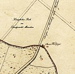
The hamlet of Oberdill takes its name in a modified form from the residence of a royal hunter who served in the southern area of what was then the "Royal Park". The land map from 1809 shows the house name "Oberer Thilljäger". In contrast, the property of the hunter responsible for the northern area of the park is called "Unterdieljäger". The word syllable -dill, which comes from Middle High German and stands for a picket fence or a wooden gate , documents the professional activity within the park, which was already fenced in at the time. The location of the hunting lodge on the Chaussee from Starnberg to Munich also marked the administrative boundary where the jurisdiction of the Munich Regional Court began.
Due to a slight border shift, the property was spun off from the area of today's Forstenrieder Park in the 19th century. In the cadastral sheets of 1866 it now appeared as "Oberdilljäger" in the municipality of Percha with the comment that the Royal Revierjäger Georg Dillis took over the property in 1841 from his father. In the list of localities from 1928, the name was shortened to the "Oberdill" in use today. It describes the place as a wasteland with a residential building that is also used for forestry and 19 residents.
On the occasion of the 1936 Winter Olympics , the road between Starnberg and Munich was expanded. The owners of the old hunting lodge took advantage of the advantageous location on the Chaussee, which is now called “Olympiastraße”, and expanded it to include the “Forsthaus Oberdill” inn. The construction of the Autobahn 95, which runs on the route of the old Chaussee near Oberdill, marked the end of the popular excursion restaurant in 1964. Since then, the offices of the motorway police have been located in the building.
Worth seeing
In Oberdill, one of the entrances to the hiking trails is in the fenced-in part of Forstenrieder Park.
The former hunting area of the Bavarian ruling house is now a wildlife park. In the almost 20 square kilometers large area, the southwest area around Oberdill is popular with visitors. On the edge of two game rest areas , the wild animals can be observed particularly well in their natural habitat.
See also
Web links
Individual evidence
- ↑ BayernPortal, Official Municipal Parts, accessed on March 15, 2018.
- ^ Johann Andreas Schmeller : Bavarian Dictionary. Volume 1/1, R. Oldenbourg Verlag, Munich 1996, ISBN 3-486-52602-2 , p. 500.
- ^ Anton Brunner: 1000 years of cheeks . Kulturverlag Starnberg, Starnberg 2010, ISBN 978-3-941167-21-6 , p. 109.
- ↑ List of localities for the Free State of Bavaria. (= Contributions to Statistics Bavaria. Issue 109). Bavarian State Statistical Office (ed.). Munich 1928.


