Embalse de Portodemouros
| Embalse de Portodemouros | |||||||
|---|---|---|---|---|---|---|---|
|
|||||||
|
|
|||||||
| Coordinates | 42 ° 50 '47 " N , 8 ° 8' 26" W | ||||||
| Data on the structure | |||||||
| Lock type: | dam | ||||||
| Construction time: | 1964-1967 | ||||||
| Building volume: | 2 350 000 m³ | ||||||
| Crown length: | 430 m | ||||||
| Power plant output: | 106 MW | ||||||
| Data on the reservoir | |||||||
| Reservoir length | 25 km | ||||||
| Storage space | 297 000 000 m³ | ||||||
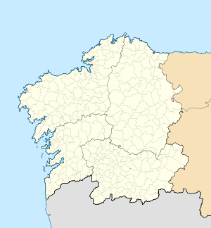
The Embalse ( Galic .: Encoro ) de Portodemouros is a dam in the Spanish autonomous region of Galicia between the provinces of A Coruña and Pontevedra (with the municipality of Agolada ).
Its dam at the western end near the hamlet of Portodemouros with a volume of 2,350,000 m³ dams the Río Ulla between the municipalities of Arzúa (La Coruña) and Villa de Cruces and Santiso (Pontevedra) up to a maximum of 297,000,000 m³ . The 430 m long dam was built between 1964 and 1967 and has a 30 m long bridge over the overflow with a discharge capacity of up to 1500 m³ / s. The height above the river is 90 m.
Two turbines commissioned in 1968 generate up to 95 MW of power. Another turbine that has been running since December 2003 produces up to 11.23 MW.
In addition to generating energy, the system is also used for flood protection .
Fishing for trout , pikeperch , perch-like and various white fish is possible; fishing licenses are issued in Lugo .
Web links
- Embalse: Postage demouros on Embalses.net
- Visita al embalse de Portodemouros y al río Ulla on iAgua.es
- Picture gallery Encoro de Portodemouros on gl.wikipedia
