Agolada
| Agolada municipality | ||
|---|---|---|
| coat of arms | Map of Spain | |

|
|
|
| Basic data | ||
| Autonomous Community : | Galicia | |
| Province : | Pontevedra | |
| Coordinates | 42 ° 46 ′ N , 8 ° 1 ′ W | |
| Area : | 147.85 km² | |
| Residents : | 2,344 (Jan 1, 2019) | |
| Population density : | 15.85 inhabitants / km² | |
| Postal code : | 36520 | |
| Municipality number ( INE ): | 36020 | |
| Location of the municipality | ||

|
||
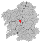
Agolada is a municipality in the northeast of the province of Pontevedra in the Spanish autonomous region of Galicia . The political center of the municipality was in the village of Borraxeiros until the middle of the 20th century, but was then moved to Agolada, a small town in the municipality of Ferreiroa.
Community structure
The municipality of Agolada is divided into 24 parroquias :
- Agra
- Artoño
- A Baíña
- Basadre
- Berredo
- Borraxeiros
- Brántega
- Brocos
- Carmoega
- Eidien
- Esperante
- Ferreiroa
- Gurgueiro
- Merlin
- Órrea
- Ramil
- San Paio de Bais
- Santa Comba
- Sesto
- Oh sex
- As trabancas
- Val de Sangorza
- Ventosa
- Vilariño
geography
The municipality of Agolada is located in an area between the Serra do Farelo Mountains and the Arnego River. The geography of the municipality is shaped by three main factors: the Serra do Farelo mountains, the gentle waves of the eroding ground and the river system around the Ulla river with its tributary Arnego.
history
In the municipality there are some megalithic remains from the period 3,000 to 1,800 BC. BC ( Neolithic ). Examples of this are the Monte das Mámoas hill, cut stone axes from the localities of O Quinteiro and Monte Laxido. The so-called Castro culture (Castros = fortified settlements made of stone in a round structure) has also left its mark. Particularly noteworthy are the Castro de Buxel and the Castro de Marcelín . In addition, fields with burial mounds and dolmens have been preserved throughout the municipality . In this context the treasure of Agolada is worth mentioning. This valuable find (two gold bracelets and necklace), which is exhibited in a museum in the provincial capital, Pontevedra , comes from a grave object in a burial mound (Galician mámoa ) near Campo da Xesta in the village of Ferreiroa.
From the Roman occupation, old traffic routes in particular have been preserved today, such as the bridge over the Ulla River in Basadre, in the municipality of Vilariño.
The city's name comes from the Latin Aqua Lata , because an aqueduct may have passed here in ancient times .
Population development of the municipality

Web links
Individual evidence
- ↑ Cifras oficiales de población resultantes de la revisión del Padrón municipal a 1 de enero . Population statistics from the Instituto Nacional de Estadística (population update).
