
A Estrada
| A Estrada | |||
|---|---|---|---|
 the town hall
|
|||
| coat of arms | Map of Spain | ||

|
|
||
| Basic data | |||
| Autonomous Community : |
|
||
| Province : | Pontevedra | ||
| Coordinates | 42 ° 41 ′ N , 8 ° 29 ′ W | ||
| Area : | 280.72 km² | ||
| Residents : | 20,479 (Jan 1, 2019) | ||
| Population density : | 72.95 inhabitants / km² | ||
| Postal code : | 36680 | ||
| Municipality number ( INE ): | 36017 | ||
| administration | |||
| Website : | www.aestrada.com | ||
| Location of the city | |||

|
|||

A Estrada ( La Estrada in Castilian ) is a Galician city in the province of Pontevedra in northwest Spain with 20,891 inhabitants (as of 2016).
The city is located in a densely populated mountainous area about 24 kilometers southeast of Santiago de Compostela . The most important branches of industry are the timber industry and the processing of dairy products .
Sights include a Romanesque church in Moreira and the manor house and gardens of Oca ( Pazo de Oca ) from the 16th and 17th centuries. Century. A little north of the city on the Ulla is the San Xóan de Cova gorge, popular with hikers .
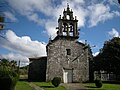
San Miguel de Moreira
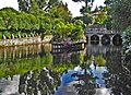
Pazo de Oca

.jpg)
Web links
Individual evidence
- ↑ Cifras oficiales de población resultantes de la revisión del Padrón municipal a 1 de enero . Population statistics from the Instituto Nacional de Estadística (population update).
Agolada | Arbo | Baiona | Barro | Bueu | Caldas de Reis | Cambados | Campo Lameiro | Cangas | A Cañiza | Catoira | Cerdedo-Cotobade | Covelo | Crecente | Cuntis | Dozón | A Estrada | Forcarei | Fornelos de Montes | Gondomar | O Grove | A Guarda | A Illa de Arousa | Lalín | A Lama | Marín | Meaño | Meis | Moaña | Mondariz | Mondariz Balneario | Moraña | Mos | As Neves | Nigrán | Oia | Pazos de Borbén | Poio | Ponte Caldelas | Ponteareas | Pontecesures | Pontevedra | O Porriño | Portas | Redondela | Ribadumia | Rodeiro | O Rosal | Salceda de Caselas | Salvaterra de Miño | Sanxenxo | Silleda | Soutomaior | Tomiño | Tui | Valga | Vigo | Vila de Cruces | Vilaboa | Vilagarcía de Arousa | Vilanova de Arousa