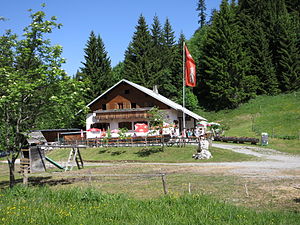
Emser hut
| Emser Hut NFI - Guest House |
||
|---|---|---|
|
The Emser Hut |
||
| location | Fluhereck ; Vorarlberg , Austria ; Valley location: Hohenems | |
| Mountain range | Bregenz Forest Mountains , Eastern Alps | |
| Geographical location: | 47 ° 21 '6 " N , 9 ° 43' 18" E | |
| Altitude | 1283 m above sea level A. | |
|
|
||
| owner | Friends of nature Hohenems local group | |
| Built | 1951-1956 | |
| Construction type | Inn | |
| Development | Freight route from Ebnit (driving ban) | |
| Usual opening times | all year round | |
| accommodation | 0 beds, 28 camps | |
| Hut directory | NFI | |
The Emser Hütte is a refuge for nature lovers at 1283 m above sea level. A. (according to own information 1298 m ) altitude in the Bregenzerwald Mountains .
Location and surroundings
The Emser Hütte is located on the Fluhereck between the town of Hohenems and the mountain village of Ebnit in Austria, which belongs to Dornbirn . The Beautiful Man rises to the northeast, the northern foothills of the Hohe Kugel to the south and the jet head to the west .
history
In 1949, Hans Wehinger signed a lease agreement with the Hohenems community for the property on which the hut stands today; it was later acquired. The members of the Hohenems Friends of Nature erected the building in 8,000 hours of voluntary work between 1951 and 1956.
ways
Approach
Tours from the Emser Hütte / summit ascents
- Alpe Schöner Mann, walking time 20 minutes
- Hohe Kugel ( 1645 m above sea level ), walking time 1 hour
Web links
Commons : Emser Hütte - Collection of images, videos and audio files

