Ebnit
| Ebnit ( village ) | ||
|---|---|---|
|
|
||
| Basic data | ||
| Pole. District , state | Dornbirn (Thu), Vorarlberg | |
| Judicial district | Dornbirn | |
| Pole. local community | Dornbirn ( KG Ebnit I , Ebnit II ) | |
| Coordinates | 47 ° 21 '0 " N , 9 ° 44' 47" E | |
| height | 1075 m above sea level A. | |
| Residents of the stat. An H. | 130 (January 1, 2016) | |
| Building status | 148 (May 15, 2001 ) | |
| surface | 21.63 km² | |
| Post Code | 6850 Dornbirn | |
| prefix | + 43/5576 ( Hohenems ) | |
| Statistical identification | ||
| Counting district / district | Ebnit (80 301 030) | |
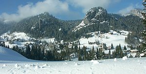
 District of Ebnit in winter |
||
| Source: STAT : index of places ; BEV : GEONAM ; VoGIS | ||
Ebnit is a mountain village in the municipality of the city of Dornbirn in Vorarlberg ( Austria ). The small village in the mountainous south of Dornbirn is a climatic health resort and, like Lech , Damüls or Mittelberg, is one of the Vorarlberg Walser villages .
geography
Ebnit is located in the mountains above the Vorarlberg Rhine Valley at an altitude of 1075 m above sea level. A. in the difficult to access Ebniterach valley on an open space on the right-hand slope of the valley. Amidst the mountain landscape of the western foothills of the eastern Alps counting Bregenzerwald mountain range, was located the village by their geographical location for centuries difficult to access. Today, Ebnit's secluded location in the middle of the Dornbirn mountains is a good starting point for hikes in the Freschenstock area .
The population of Ebnit was 111 people (main residences) in the last census in 2011. In addition to these year-round residents, there are also some people who have a holiday or second home in Ebnit and use it especially in the summer months.
history
In the late Middle Ages, people from the Swiss canton of Valais were forced to leave their homes and look for new living spaces because of poverty. In Vorarlberg , in the west of Tyrol and in Graubünden remote, impassable and undeveloped valleys were made available to them for clearing and settlement. The Walsers were considered free people (i.e. not serfs ). The establishment of the Walser branch in Ebnit is documented in a document from 1351 with the first mention of "Ebenot". Etymologically, the place name most likely indicates a flat surface in mountainous terrain, as has already been proven with other, similar place names.
A dispute over whether Ebnites who had migrated into the valley to Dornbirn should now be considered serfs or not put an end to the Walser freedoms in 1539, and the Ebnites were declared serfs of the Count of Hohenems . In 1806 Ebnit gained the status of its own municipality and thus the separation from the imperial county of Hohenems.
In 1921, the then independent municipality of Ebnit signed a contract with the city of Dornbirn for the construction of Ebniterstraße from Dornbirn to Ebnit. In 1927 the road that leads through the wild and romantic Ebniterache valley , past the Rappenloch Gorge , was completed. In the same year there was a serious fire disaster in which the church, school and rectory were destroyed. Because of this catastrophe and the expensive road construction, the community got into serious financial difficulties and could no longer meet its payments. This means that Ebnit in 1932 in the city of Dornbirn incorporated was.
Another significant event for the village was the collapse of the Rappenloch Bridge, which spanned the Ebniter Ache at a height of 70 m, in May 2011. No one was harmed at the time. The cause was rock movements in the area of the abutments. Until a temporary bridge was built, which was released 44 days later, Ebnit could only be approached via forest roads. A new bridge that was elaborately anchored in the rock should originally be ready in 2020.
On the night of March 18-19, 2020, another 10,000 m³ rock fall fell below the temporary bridge. This remained due to its anchoring deep in the rock, but has become unstable and blocked because of the rock eruptions directly below it. Fundamentally revised plans to develop the Ebnit by road have now become necessary.
Local infrastructure
Due to its remote location and the small number of inhabitants, Ebnit has not had an independent elementary school since 2014 . Up until then, the Ebniter elementary school was the smallest school in Vorarlberg with at times only four students and one teacher. There is also a fire station in Ebnit for the Dornbirn volunteer fire brigade , which maintains a fire fighting group in the village . Medical care is provided by trained “ first responders ”, i.e. private individuals with basic medical training. Since 2009, the small mountain village also has its own, fully automated and remotely monitored wastewater treatment plant . In winter there is the Heumöserlift, which belongs to the municipal Dornbirn cable car company, a drag lift for skiers.
Ebnit is connected to the city of Dornbirn by the Ebniterstraße built in the 1920s . This can be used both by private transport and by a regular regional bus on line 46. In this way, Ebnit is connected to Dornbirn train station within 48 minutes by public transport . In addition to Dornbirn, Ebnit is also connected to the city of Hohenems via Emsreute , but this connection is not suitable for traffic and can therefore only be used in emergencies.
The small Catholic parish church in the center of Ebnit is called the Parish Church of St. Maria Magdalena . In Ebnit there was a monastery of the Augustinian hermits from around 1351 to 1377 . After a fire in 1508, a new building was built in 1515. In 1927 another fire destroyed the parish building. In 1928/29 the new building took place according to plans by Alfons Fritz .
The iron-containing mineral spring, which at the turn of the 19th / 20th centuries It was used diligently in the 19th century (up to 50 spa guests are said to have come to drink the water every day) has not been in operation for a long time.
tourism
Although the place is quiet in the middle of the mountains, there is hardly any tourism here. There are only two inns (with guest rooms), a Kolping family holiday village , a sports center and a few private landlords. Ebnit is the starting point for various hikes.
We recommend the path to the Hohe Freschen , which however requires surefootedness, as the path leads over the steep Binnelgrat. The two mountain peaks Große and Kleine Klara tower above the mountain village itself.
Various paths leading into the nearby forests are also wildly romantic. A hiking trail leads from the Niedere to the nearby village of Kehlegg (also the municipality of Dornbirn). The paths to the nearby gorges, such as the Rappenloch Gorge or the Alploch Gorge, are also very popular . From here it is also possible to climb Dornbirn's local mountain, the Karren .
literature
- Walter Wohlgenannt: The Ebniter Village Book . Dornbirn, 2003.
- Stadtarchiv Dornbirn (ed.): 650 years of the Walser settlement Ebnit (Dornbirn writings. Volume 28). Dornbirn, 2001. ISBN 3-901900-09-8
- Arbeitsgemeinschaft Ebnit (Ed.): Ebnit (Dornbirner Schriften. Special Issue No. 1). Dornbirn, 1992.
Web links
Individual evidence
- ^ Franz Kalb: Place names in Dornbirn . In: Stadtarchiv Dornbirn (Hrsg.): Dornbirner Schriften - Contributions to urban history . Volume 41. Dornbirn, 2012. ISBN 978-3-901900-33-4 . P. 13.
- ↑ Rappenlochbrücke is open again. Retrieved May 2, 2019 .
- ↑ When the excavator takes action on the precipice. Retrieved May 2, 2019 .
- ↑ vorarlberg ORF at red: Another rock fall in the Rappenloch Gorge. March 19, 2020, accessed March 19, 2020 .
- ↑ Thomas Matt: Four students were not enough . Article in the Vorarlberger Nachrichten of July 2, 2014.
- ↑ Now it is clarified: New plant opened . Article by ORF Vorarlberg from October 16, 2009.
- ↑ Christoph Vallaster: Kleines Vorarlberger Heilbäderbuch , p. 140.


