High fresch
| High fresch | ||
|---|---|---|
|
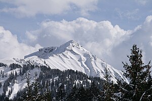
The Hohe Freschen as seen from Ebnit (from the northwest) |
||
| height | 2004 m above sea level A. | |
| location | Vorarlberg , Austria | |
| Mountains | Bregenz Forest Mountains | |
| Dominance | 4.1 km → Sünser Spitze | |
| Notch height | 216 m ↓ Gäviser Höhe | |
| Coordinates | 47 ° 18 '25 " N , 9 ° 46' 40" E | |
|
|
||
| rock | Drusberg Formation , Garschella Formation , Seewen Formation | |
| Age of the rock | Middle Barremium - Lower Coniacium | |
| Normal way | Hiking trail from Bad Laterns | |
The Hohe Freschen , in the local dialect / frœʃa / , is a 2004 m above sea level. A. high mountain in the western part of the Bregenz Forest Mountains , high above the Rhine Valley and the Laternsertal .
location
The summit of the Hohe Freschen forms the highest point of the so-called Freschenstock, a series of several mountain peaks connected to one another. The four municipal areas of Dornbirn , Laterns , Zwischenwasser and Viktorsberg meet at the top of the Hohe Freschen . The summit belongs to the Freschengruppe named after him , a mountain range in the Bregenzerwald Mountains.
The Dornbirner Ach , an approximately 30-kilometer-long river that flows into Lake Constance , has its source on the north-western flank of the mountain . The most famous refuge , the Freschenhaus , is located a little south of the summit at 1840 m above sea level. A.
Direction and distance to Hohen Freschen of the following places: Rankweil 501 m (66 ° - 10.9 km), Ebnit 1,074 m (149 ° - 5.4 km), Mellau 684 m (237 ° - 9.2 km), Damüls 1,424 m (287 ° - 9 km), Laterns 927 m (50 ° - 7.2 km).
Ascents
- From the Freschenhaus in about 45 minutes
- From the Unterfluhalpe over the Fluhlöchle and Binnelgrat in about 2¼ hours (only for experienced)
- From Ebnit on the Alpe Valor and Valüragrat about 3¼ hours (only for experienced hikers with surefootedness and head for heights!)
Adjacent peaks
(Height - distance - direction)
- High sphere 1,645 m (5,636 m - 302 °)
- Alpkopf 1,788 m (2,436 m - 353 °)
- Mörzelspitze 1,830 m (4,976 m - 29 °)
- Sünserspitze 2,061 m (4,318 m - 94 °)
- Matona 1,998 m (1,386 m - 143 °)
- Nob 1,785 m (3,037 m - 200 °)
base
- Freschenhaus (1840 m)
Word meaning
The name Freschen (also Frexen, Fröschen) is related to the words fressen or eat, which are still used today, and should refer to grazing on the slopes or mowing . Adelung also mentions "fretzen", "frexen", "atzen" as related words to "eat" in his grammatical-critical dictionary of the High German dialect. Similar meaning in Hoher Fraßen .
Literature and map
- National map of Switzerland 1: 25,000, sheet 1096 Diepoldsau ,
- National map of Switzerland 1: 25,000, sheet 1116 Feldkirch ,
- National map of Switzerland 1: 50,000, sheet 228 Hoher Freschen.
- Compass map 1: 50,000, sheet 2 Bregenzerwald - Westallgäu,
- Dieter Seibert : Bregenzerwald and Lechquellen Mountains. Alpine Club Guide alpine. 1st edition. Bergverlag Rother, Munich 2008, ISBN 978-3-7633-1095-1 .
Web links
- Entry on Hoher Freschen in the Austria Forum (in the AEIOU Austria Lexicon )
- Panorama from the Hoher Freschen


