Cart (mountain)
| Carts | ||
|---|---|---|
|
View from the Bürgle to the cart |
||
| height | 971 m above sea level A. | |
| location | Dornbirn , Vorarlberg , Austria | |
| Mountains | Schuttannenberge , Bregenz Forest Mountains | |
| Dominance | 0.4 km → Staufen | |
| Notch height | 30 m ↓ Kühberg | |
| Coordinates | 47 ° 23 '14 " N , 9 ° 45' 3" E | |
|
|
||
| Type | Fallback Hill | |
| rock | Schrattenkalk | |
| Development | Karrenseilbahn | |
| Normal way | Walk from the valley station of the cable car | |
|
View from Hatlerdorf to the summit of the Karren |
||
|
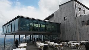
Panorama restaurant at the summit of the Karren |
||
|
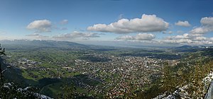
180 ° panorama from the summit of the Karren |
||
The carts (according to the frequently occurring in limestone carts ) is the local mountain of Dornbirn in Vorarlberg , Austria . It is 971 meters high and belongs to the group of Schuttannenberge in the Bregenz Forest Mountains . Despite its low dominance and notch height, it has been listed as an independent mountain on official maps since it was made accessible by the Karrenseilbahn . There is a panorama restaurant on the top of the mountain.
On individual maps, signposts and brochures, the height is given as 976 meters, but this is the cable height of the mountain station of the Karrenseilbahn cable car.
Location and surroundings
The cart is located southeast of the Dornbirn district of Hatlerdorf , completely in the municipality of the city of Dornbirn.
The striking rock face of the Karren continues southwest in the Breitenberg , separated by the Feientobel and the Fallbach . In the south, the cart is connected to the Staufen via the saddle at Kühberg , which, with its foothills separated by the Küferbach (Dornbirn) , also encloses the cart on the east side. In the northwest, the rocky edge of the Karren falls into the Vorarlberg Rhine Valley .
geology
The Schrattenkalk of the Karren is part of the Säntis ceiling of the Helvetic ceiling system , which extends below the Rhine plain into the Eastern Alps. The cart forms the north-western cornerstone of the Helvetian zone of the Eastern Alps .
Landscape and nature conservation
The north and west sides of the Karren are dominated by steep Schrattenkalk cliffs , while south of the summit the ridge line to the saddle at Kühberg only drops by about 30 meters.
In the limestone cliffs stands of Scots pine mix with individually sprinkled whitebeams , dog roses , rock pears and a variety of herbs. At the foot of a rock face exposed to the northeast there is an originally preserved deer tongue - maple forest .
The entire west-facing slope of the Karren lies in the protected landscape area Haslach-Breitenberg . A particularly sensitive section of this rock wall is under the number 30117 in the biotope inventory Vorarlberg entered that as a special occurrence of the highly endangered Pigeon Skabiose and the Endangered Species keeled leeks , Willow Gentian , European holly and Tower Cress identifies.
The deer tongue maple forest at the foot of the northeast flank is listed in the biotope inventory under number 30118. Due to the low use, it is formed with a high proportion of fallen and dead wood. In addition to the mountain maple , which is often covered with thick moss carpets , the common ash and mountain elm dominate the tree population. In the herb layer , the endangered broad-leaved bellflower should be emphasized.
Development, use and tourism
In addition to the Karrenseilbahn cable car , there is also a steep gravel road leading to the summit, on which driving is prohibited. The cart can be climbed on foot from several starting points in the valley.
The Karren is a popular destination for the local population. It is the ideal starting point for hikes to the peaks of the surrounding Schuttannenberge , but also to Schuttannen , Ebnit , Staufensee and the Rappenloch and Alploch gorges . The Karren is a popular starting point for hang-glider pilots due to the good thermals towards the Alpine Rhine Valley .
The entire summit plateau is taken up by the panorama restaurant, to whose building the mountain station of the cable car is directly connected. A freely accessible footbridge, the "cart edge", protrudes under the restaurant twelve meters above the cliff.
The gravel path between the valley station and the mountain station of the cable car, which is divided into a steeper and a less steep variant in the upper half, is a popular training route for runners and hikers with the 513 meters of altitude that it overcomes. Electronic timekeeping at the valley and mountain stations allows exact runtime measurement and documentation of the result on an automatically printed ticket.
Web links
Individual evidence
- ↑ Walther Flaig : Alpine Club Guide Bregenzerwaldgebirge . 1st edition. Bergverlag Rudolf Rother, Munich 1977, ISBN 3-7633-1203-X , margin number 721, p. 295-296 .
- ^ Vorarlberg state government, environmental protection department (IVe): Update of the Vorarlberg biotope inventory, Dornbirn municipality - mountain area . 2014, Geography and Geology, pp. 9 ( vorarlberg.at [PDF; 5.4 MB ; accessed on August 4, 2016]).
- ^ Rudolf Oberhauser : On the geology of the Staufenspitz group south of Dornbirn . In: Vorarlberger Naturschau . No. 16 . Inatura , Dornbirn 2005, p. 109–152 ( PDF on ZOBODAT ).
- ^ A b Vorarlberger Landesregierung, Environmental Protection Department (IVe): Update of the Vorarlberg biotope inventory, Dornbirn municipality - mountain area . 2014, Felsen am Karren (Biotop 30117), p. 17 ( vorarlberg.at [PDF; 5.4 MB ; accessed on August 4, 2016]).
- ^ A b Vorarlberger Landesregierung, Environmental Protection Department (IVe): Update of the Vorarlberg biotope inventory, Dornbirn municipality - mountain area . 2014, Hirschzungen - Ahornwald im Küferbachtobel (Biotop 30118), p. 18 (apps: //www.vorarlberg.at/archiv/umweltschutz/biotopinventar/Dornbirn_Berg.pdf [PDF; 5.4 MB ; accessed on August 4, 2016]).
- ↑ Barrow Edge. In: Karren Dornbirn online. Dornbirner Seilbahn GmbH, accessed on August 4, 2016 .
- ↑ There is a permanently installed timing system at the Karren valley and mountain stations. In: Karren Dornbirn online. Dornbirner Seilbahn GmH, accessed on August 4, 2016 .


